IMAGES TAKEN NEAR TO
St. Ervans Road, LONDON, W10 5QX
Introduction
This page details the photographs taken nearby to St. Ervans Road, W10 5QX by members of the Geograph project.
The Geograph project started in 2005 with the aim of publishing, organising and preserving representative images for every square kilometre of Great Britain, Ireland and the Isle of Man.

There are currently over 7.5m images from over14,400 individuals and you can help contribute to the project by visiting https://www.geograph.org.uk
Image Map
Images are licensed for reuse under creativecommons.org/licenses/by-sa/2.0
Notes
- Clicking on the map will re-center to the selected point.
- The higher the marker number, the further away the image location is from the centre of the postcode.
Image Listing (390 Images Found)
Images are licensed for reuse under creativecommons.org/licenses/by-sa/2.0
Image
Details
Distance
1
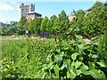
Acklam Road Wildflower Meadow
Also pictured: Al-Manaar, the Muslim Cultural Heritage Centre, and Trellick Tower
Image: © Ibn Musa
Taken: 16 May 2015
0.05 miles
2
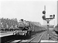
Westbourne Park, GWR 1946
View westward from the end of the Slow line platform of the main line station, which was closed 16/3/92, leaving the London Underground Hammersmith & City station only. On an Up Worcester express is 'Castle' 4-6-0 No. 4086 'Builth Castle', which was built in 6/25 and withdrawn in 4/62.
Image: © Ben Brooksbank
Taken: 22 Jun 1946
0.06 miles
3
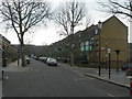
Wornington Road, W10 (2)
Near Orchard Close.
Image: © Danny P Robinson
Taken: 4 Feb 2007
0.08 miles
5
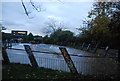
Acklam Road, W10
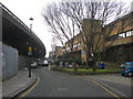
The flyover to the left of the picture carries the busy A40 Westway. I do not know if the local authority flats on the right hand side were built before or after the flyover -- it must be an extremely noisy and polluted environment in which to live.
Image: © Danny P Robinson
Taken: 4 Feb 2007
0.08 miles
6
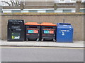
Recycle and knife bins, Golborne Road W10
Image: © Robin Sones
Taken: 13 Feb 2013
0.09 miles
7
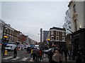
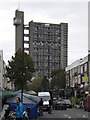
View of Trellick Tower from Golborne Road
This peculiar-looking block of flats is located further down Golborne Road, at the junction of Golborne Gardens and Hazelwood Crescent. An extreme close-up of the tower block (which I won't post here on Geograph as it may not comply with its requirements) makes me think the tall, slender structure next to the block of flats itself is the lift shaft, and the horizontal "reins" in between are corridors leading from the lifts to the flats. The Royal Borough of Kensington and Chelsea certainly seems to love its wacky and gaudy architecture! Looking northeast from outside the Fat Badger pub.
Image: © Robert Lamb
Taken: 20 Nov 2010
0.10 miles
8
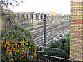
Main railway line into Paddington
Viewed from the eastern side of Golborne Road railway bridge.
Image: © Stuart Logan
Taken: 22 Jan 2012
0.10 miles
10
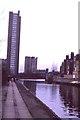
Grand Union Canal, Westbourne Park, 1988
Ahead, Erno Goldfinger's iconic Trellick Tower.
Image: © Christopher Hilton
Taken: 7 Feb 1988
0.11 miles