IMAGES TAKEN NEAR TO
Wornington Road, LONDON, W10 5QW
Introduction
This page details the photographs taken nearby to Wornington Road, W10 5QW by members of the Geograph project.
The Geograph project started in 2005 with the aim of publishing, organising and preserving representative images for every square kilometre of Great Britain, Ireland and the Isle of Man.

There are currently over 7.5m images from over14,400 individuals and you can help contribute to the project by visiting https://www.geograph.org.uk
Image Map
Images are licensed for reuse under creativecommons.org/licenses/by-sa/2.0
Notes
- Clicking on the map will re-center to the selected point.
- The higher the marker number, the further away the image location is from the centre of the postcode.
Image Listing (382 Images Found)
Images are licensed for reuse under creativecommons.org/licenses/by-sa/2.0
Image
Details
Distance
1
Acklam Road, W10
The flyover to the left of the picture carries the busy A40 Westway. I do not know if the local authority flats on the right hand side were built before or after the flyover -- it must be an extremely noisy and polluted environment in which to live.
Image: © Danny P Robinson
Taken: 4 Feb 2007
0.04 miles
2
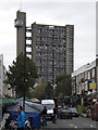
Acklam Road Wildflower Meadow
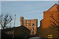
Also pictured: Al-Manaar, the Muslim Cultural Heritage Centre, and Trellick Tower
Image: © Ibn Musa
Taken: 16 May 2015
0.06 miles
3
Wornington Road, W10 (2)
Near Orchard Close.
Image: © Danny P Robinson
Taken: 4 Feb 2007
0.07 miles
4
View of Trellick Tower from Acklam Road
Looking north-northeast.
Image: © Robert Lamb
Taken: 4 Dec 2016
0.07 miles
5
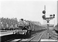
Westbourne Park, GWR 1946
View westward from the end of the Slow line platform of the main line station, which was closed 16/3/92, leaving the London Underground Hammersmith & City station only. On an Up Worcester express is 'Castle' 4-6-0 No. 4086 'Builth Castle', which was built in 6/25 and withdrawn in 4/62.
Image: © Ben Brooksbank
Taken: 22 Jun 1946
0.09 miles
6
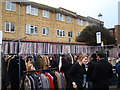
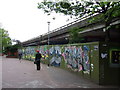
Wall on Portobello Road
The northeastern end of Portobello Road beyond the Hammersmith and City line and A40 bridges is lined with a very interesting wall which has plastic boarding with the spines of LP sleeves on it. I suppose this has been done in order to reflect the number of record shops and stalls in the area. I'm not sure if this is a recent idea or one that has been here for some time - the Streetview of the location (as near as I could get it, the car obviously hasn't covered this section of the road) (http://www.google.co.uk/maps?f=q&source=s_q&hl=en&geocode=&q=Portobello+Road,+Kensington&sll=53.800651,-4.064941&sspn=20.594096,62.53418&ie=UTF8&hq=&hnear=Portobello+Rd,+Kensington,+Greater+London,+United+Kingdom&ll=51.521076,-0.209619&spn=0.021095,0.061069&z=15&layer=c&cbll=51.521076,-0.209619&panoid=MTtW7bTtmJP80DrNBKKxNQ&cbp=12,134.4,,0,2.87) doesn't show it being there. It's certainly a very inventive and thoughtful idea! Looking east-southeast.
Image: © Robert Lamb
Taken: 20 Nov 2010
0.11 miles
7
View of trees and apartments on Acklam Road from the Portobello Road Winter Festival
Looking north-northeast.
Image: © Robert Lamb
Taken: 4 Dec 2016
0.12 miles
8
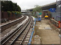
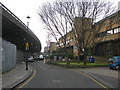
Railway line to the west of Westbourne Park tube station
An elevated section of the A40 'Westway' can be seen on the right
Image: © Oxyman
Taken: 9 Apr 2009
0.12 miles
9
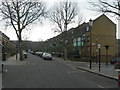
Acklam Road, Ladbroke Grove
Running parallel to the Westway.
Image: © Chris Whippet
Taken: 30 Apr 2009
0.12 miles