IMAGES TAKEN NEAR TO
St. Ervans Road, LONDON, W10 5QA
Introduction
This page details the photographs taken nearby to St. Ervans Road, W10 5QA by members of the Geograph project.
The Geograph project started in 2005 with the aim of publishing, organising and preserving representative images for every square kilometre of Great Britain, Ireland and the Isle of Man.

There are currently over 7.5m images from over14,400 individuals and you can help contribute to the project by visiting https://www.geograph.org.uk
Image Map
Images are licensed for reuse under creativecommons.org/licenses/by-sa/2.0
Notes
- Clicking on the map will re-center to the selected point.
- The higher the marker number, the further away the image location is from the centre of the postcode.
Image Listing (399 Images Found)
Images are licensed for reuse under creativecommons.org/licenses/by-sa/2.0
Image
Details
Distance
1
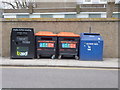
Recycle and knife bins, Golborne Road W10
Image: © Robin Sones
Taken: 13 Feb 2013
0.06 miles
3
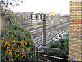
Main railway line into Paddington
Viewed from the eastern side of Golborne Road railway bridge.
Image: © Stuart Logan
Taken: 22 Jan 2012
0.06 miles
4
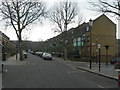
Wornington Road, W10 (2)
Near Orchard Close.
Image: © Danny P Robinson
Taken: 4 Feb 2007
0.06 miles
5
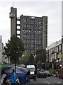
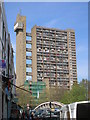
Golborne Road, North Kensington
Looking towards the famous Trellick Tower, which I have never taken before and hardly remember seeing as this is some way from the main through roads.
Image: © David Howard
Taken: 26 Oct 2023
0.07 miles
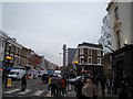
6
Golborne Road, London W10
Looking towards Trellick Tower - the bridge in the picture straddles the Metropolitan and City Underground line.
Image: © Robin Sones
Taken: 26 Apr 2008
0.08 miles
7
Golborne Halal Butcher, Golborne Road W10
Image: © Robin Sones
Taken: 16 Apr 2010
0.08 miles
8
View of Trellick Tower from Golborne Road
This peculiar-looking block of flats is located further down Golborne Road, at the junction of Golborne Gardens and Hazelwood Crescent. An extreme close-up of the tower block (which I won't post here on Geograph as it may not comply with its requirements) makes me think the tall, slender structure next to the block of flats itself is the lift shaft, and the horizontal "reins" in between are corridors leading from the lifts to the flats. The Royal Borough of Kensington and Chelsea certainly seems to love its wacky and gaudy architecture! Looking northeast from outside the Fat Badger pub.
Image: © Robert Lamb
Taken: 20 Nov 2010
0.08 miles
9
Benchmark on the wall of Portobello Bridge next to Earl of Portobello pub
Ordnance Survey cut mark benchmark described on the Bench Mark Database at http://www.bench-marks.org.uk/bm38020
Image: © Roger Templeman
Taken: 20 May 2011
0.09 miles
10
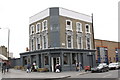
The Earl of Portobello public house, Golborne Road
There is an OS benchmark Image on the grey wall abutting the bridge at the left hand side of the photo.
Image: © Roger Templeman
Taken: 20 May 2011
0.09 miles