IMAGES TAKEN NEAR TO
Southam Street, LONDON, W10 5PH
Introduction
This page details the photographs taken nearby to Southam Street, W10 5PH by members of the Geograph project.
The Geograph project started in 2005 with the aim of publishing, organising and preserving representative images for every square kilometre of Great Britain, Ireland and the Isle of Man.

There are currently over 7.5m images from over14,400 individuals and you can help contribute to the project by visiting https://www.geograph.org.uk
Image Map
Images are licensed for reuse under creativecommons.org/licenses/by-sa/2.0
Notes
- Clicking on the map will re-center to the selected point.
- The higher the marker number, the further away the image location is from the centre of the postcode.
Image Listing (361 Images Found)
Images are licensed for reuse under creativecommons.org/licenses/by-sa/2.0
Image
Details
Distance
1
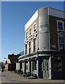
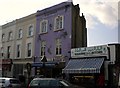
Earl of Portobello
The pub (also shown in Image is on the corner of Golborne Road (left, crossing Portobello Bridge) and Southam Street. The blue plaque commemorates the murder of Kelso Cochrane close by on 17th May 1959, and was unveiled in 2009 on the 50th anniversary of the murder http://en.wikipedia.org/wiki/Murder_of_Kelso_Cochrane .
The pub has been renamed several times; past names include the Earl of Warwick and the Golborne Grove.
Image: © Derek Harper
Taken: 19 Mar 2012
0.02 miles
2
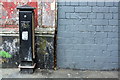
Benchmark on the wall of Portobello Bridge next to Earl of Portobello pub
Ordnance Survey cut mark benchmark described on the Bench Mark Database at http://www.bench-marks.org.uk/bm38020
Image: © Roger Templeman
Taken: 20 May 2011
0.02 miles
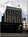
3
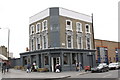
The Earl of Portobello public house, Golborne Road
There is an OS benchmark Image on the grey wall abutting the bridge at the left hand side of the photo.
Image: © Roger Templeman
Taken: 20 May 2011
0.02 miles
4
London, North Kensington
Golborne Road, at the northern end of Portobello Road, is the heart of London's Portuguese community. Trellick Tower is Britain's tallest residential tower block.
Image: © Rosalind Mitchell
Taken: 2 Nov 2002
0.03 miles
5
Golborne Halal Butcher, Golborne Road W10
Image: © Robin Sones
Taken: 16 Apr 2010
0.04 miles
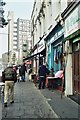
6
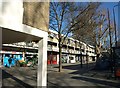
Shops on Golborne Road, W10
Towards the end of this parade are Kensal Library (a ramp with blue railings) and a Medical Centre.
Image: © Derek Harper
Taken: 19 Mar 2012
0.04 miles
7
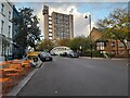
Portobello Bridge, Golborne Road W10
At the junction with Southam Street W10
Image: © Robin Sones
Taken: 16 Apr 2010
0.04 miles
8
Golborne Road, North Kensington
Looking towards the famous Trellick Tower, which I have never taken before and hardly remember seeing as this is some way from the main through roads.
Image: © David Howard
Taken: 26 Oct 2023
0.05 miles
9
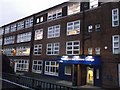
Kensington and Chelsea College
As seen from Wornington Road.
See the wiki-link for details about the college -https://en.wikipedia.org/wiki/Kensington_and_Chelsea_College
Image: © David Anstiss
Taken: 6 Dec 2013
0.05 miles
10
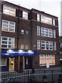
Kensington and Chelsea College
As seen from Wornington Road.
See the wiki-link for details about the college - https://en.wikipedia.org/wiki/Kensington_and_Chelsea_College
Image: © David Anstiss
Taken: 6 Dec 2013
0.05 miles