IMAGES TAKEN NEAR TO
Shrewsbury Street, LONDON, W10 5JD
Introduction
This page details the photographs taken nearby to Shrewsbury Street, W10 5JD by members of the Geograph project.
The Geograph project started in 2005 with the aim of publishing, organising and preserving representative images for every square kilometre of Great Britain, Ireland and the Isle of Man.

There are currently over 7.5m images from over14,400 individuals and you can help contribute to the project by visiting https://www.geograph.org.uk
Image Map
Images are licensed for reuse under creativecommons.org/licenses/by-sa/2.0
Notes
- Clicking on the map will re-center to the selected point.
- The higher the marker number, the further away the image location is from the centre of the postcode.
Image Listing (184 Images Found)
Images are licensed for reuse under creativecommons.org/licenses/by-sa/2.0
Image
Details
Distance
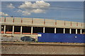
1
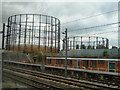
Kensal Gas Works
Nestling in between the Grand Union Canal and the Great Western Railway.
Image: © Claire Ward
Taken: 10 Jun 2005
0.06 miles
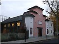
2
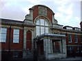
Sun Hill police station (former)
OK, it's fiction but when the TV show The Bill first started in 1983/4, this was one of the first (exterior shots) police station. The rest of it (the studios) were around the back somewhere, before it transformed into housing. Before that it was known to locals as Rootes Hall or Ladbroke Hall, (according to the bookmakers Ladbrokes, that's how it adopted their name because of this building). Rootes were a famous car manufacturer and dealership, all of which has long gone into history...... You can just make out the Rootes crest above the window.
Image: © Phillip Perry
Taken: 19 Jul 2008
0.08 miles
4
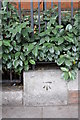
Benchmark on wall of Ladbroke Hall, Barlby Road
Ordnance Survey cut mark benchmark described on the Bench Mark Database at http://www.bench-marks.org.uk/bm38117
Image: © Roger Templeman
Taken: 27 May 2011
0.09 miles
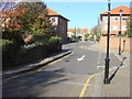
5
St Francis Community Church
On Dalgarno Gardens (road).
Image: © David Anstiss
Taken: 6 Dec 2013
0.10 miles
9
Benchmark on Pall Mall Deposit, Barlby Road
Ordnance Survey cut mark benchmark described on the Bench Mark Database at http://www.bench-marks.org.uk/bm38116
Image: © Roger Templeman
Taken: 27 May 2011
0.12 miles
10
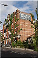
Pall Mall Deposit, #124-128 Barlby Street
Building now converted to office space and restaurant.
Image: © Roger Templeman
Taken: 27 May 2011
0.12 miles