IMAGES TAKEN NEAR TO
St. Josephs Close, LONDON, W10 5GL
Introduction
This page details the photographs taken nearby to St. Josephs Close, W10 5GL by members of the Geograph project.
The Geograph project started in 2005 with the aim of publishing, organising and preserving representative images for every square kilometre of Great Britain, Ireland and the Isle of Man.

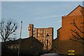
There are currently over 7.5m images from over14,400 individuals and you can help contribute to the project by visiting https://www.geograph.org.uk
Image Map
Images are licensed for reuse under creativecommons.org/licenses/by-sa/2.0
Notes
- Clicking on the map will re-center to the selected point.
- The higher the marker number, the further away the image location is from the centre of the postcode.
Image Listing (241 Images Found)
Images are licensed for reuse under creativecommons.org/licenses/by-sa/2.0
Image
Details
Distance
1
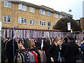
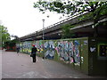
Wall on Portobello Road
The northeastern end of Portobello Road beyond the Hammersmith and City line and A40 bridges is lined with a very interesting wall which has plastic boarding with the spines of LP sleeves on it. I suppose this has been done in order to reflect the number of record shops and stalls in the area. I'm not sure if this is a recent idea or one that has been here for some time - the Streetview of the location (as near as I could get it, the car obviously hasn't covered this section of the road) (http://www.google.co.uk/maps?f=q&source=s_q&hl=en&geocode=&q=Portobello+Road,+Kensington&sll=53.800651,-4.064941&sspn=20.594096,62.53418&ie=UTF8&hq=&hnear=Portobello+Rd,+Kensington,+Greater+London,+United+Kingdom&ll=51.521076,-0.209619&spn=0.021095,0.061069&z=15&layer=c&cbll=51.521076,-0.209619&panoid=MTtW7bTtmJP80DrNBKKxNQ&cbp=12,134.4,,0,2.87) doesn't show it being there. It's certainly a very inventive and thoughtful idea! Looking east-southeast.
Image: © Robert Lamb
Taken: 20 Nov 2010
0.01 miles
2
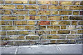
Benchmark on roadside wall of former Dominican Convent on Portobello Road
Ordnance Survey cut mark benchmark described on the Bench Mark Database at http://www.bench-marks.org.uk/bm38030
Image: © Roger Templeman
Taken: 20 May 2011
0.02 miles
3
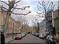
They're trees Jim - but not as we know them!
This is the eastern end of Raddington Road, just where it crosses Portobello Road. The trees are London plane Plantanus x acerifolia, a hybrid with characteristic piebald bark. This natural bark-shedding feature makes the trees pollution tolerant because absorbed, airborne pollutants are shed with the old bark. Here they have been branch pollarded and, in the spring, will produce new growth from the knobbly ends.
Image: © Stuart Logan
Taken: 22 Jan 2012
0.05 miles
4
Instituto Espanol Canada Blanch
Clearly some kind of Spanish institution. Looking east-southeast.
Image: © Robert Lamb
Taken: 20 Nov 2010
0.06 miles
5
View of Trellick Tower from Acklam Road
Looking north-northeast.
Image: © Robert Lamb
Taken: 4 Dec 2016
0.06 miles
6
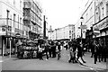
Portobello Market, Notting Hill, London
Street scene from Portobello Market, Notting Hill, London. This year I will go and do more photography in London.
Image: © Asian Wedding Photographer London
Taken: 24 Feb 2012
0.06 miles
7
View of trees and apartments on Acklam Road from the Portobello Road Winter Festival
Looking north-northeast.
Image: © Robert Lamb
Taken: 4 Dec 2016
0.07 miles
8
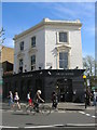
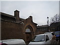
The Fat Badger, Goldborne Road, London W10
At the Junction with Bevington Road, London W10
Image: © Robin Sones
Taken: 26 Apr 2008
0.07 miles
9
Acklam Road, Ladbroke Grove
Running parallel to the Westway.
Image: © Chris Whippet
Taken: 30 Apr 2009
0.08 miles
10
View of the rear of houses on Blagrove Road and Raddington Road from Acklam Road
Looking north-northeast.
Image: © Robert Lamb
Taken: 4 Dec 2016
0.08 miles