IMAGES TAKEN NEAR TO
Hazlewood Crescent, LONDON, W10 5FU
Introduction
This page details the photographs taken nearby to Hazlewood Crescent, W10 5FU by members of the Geograph project.
The Geograph project started in 2005 with the aim of publishing, organising and preserving representative images for every square kilometre of Great Britain, Ireland and the Isle of Man.

There are currently over 7.5m images from over14,400 individuals and you can help contribute to the project by visiting https://www.geograph.org.uk
Image Map
Images are licensed for reuse under creativecommons.org/licenses/by-sa/2.0
Notes
- Clicking on the map will re-center to the selected point.
- The higher the marker number, the further away the image location is from the centre of the postcode.
Image Listing (353 Images Found)
Images are licensed for reuse under creativecommons.org/licenses/by-sa/2.0
Image
Details
Distance
1
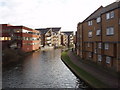
Flats by the Grand Union Canal
The flats on the left are between the canal and Harrow Road, those on the right are on Kensal Road. Photo from footbridge opposite Second Avenue.
Image: © David Hawgood
Taken: 4 Jan 2007
0.01 miles
2
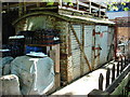
Wagon body
An old railway wagon body in use as a storage facility.
Image: © Oxyman
Taken: 23 May 2007
0.01 miles
3
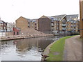
Demolition site by the Grand Union Canal
In the last month or so a red brick building which was on the left of the canal has been demolished. See Image for the building in use in January 2007.
Image: © David Hawgood
Taken: 28 Nov 2007
0.01 miles
4
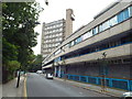
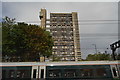
Kensal Road and Trellick Tower, Kensal Town
Kensal Road in inner north west London.
In the background is Trellick Tower, a 31-storey block of council flats built in the early 1970s. Trellick Tower was designed by architect Ernö Goldfinger, in a brutalist style, and is now a Grade II listed building.
Image: © Malc McDonald
Taken: 29 Aug 2015
0.03 miles
5
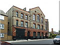
Cobden Working Men's Club and Institute, Kensal Road
Image: © Alexander P Kapp
Taken: 17 Jul 2012
0.03 miles
7
Meanwhile Gardens and Trellick Tower
These community gardens provide an island of greenery and natural growth in a crowded urban environment where private gardens are few and far between. Trellick Tower in Golbourne Road looms above.
Image: © Natasha Ceridwen de Chroustchoff
Taken: 14 Mar 2010
0.03 miles
8
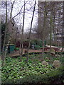
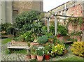
In Meanwhile Gardens
Meanwhile Gardens is a community garden, established in 1976 between the Grand Union Canal and the brutalist Trelick Tower which looms over it. It has been threatened with development for many years but still survives.
The history of Meanwhile Gardens can be seen at https://meanwhile-gardens.org.uk/history/16
Image: © Marathon
Taken: 28 Mar 2022
0.04 miles
9
In Meanwhile Gardens
Meanwhile Gardens is a community garden, established in 1976 between the Grand Union Canal and the brutalist Trelick Tower which looms over it. It has been threatened with development for many years but still survives.
The history of Meanwhile Gardens can be seen at https://meanwhile-gardens.org.uk/history/16 A close up of the sculpture on the right can be seen at https://www.geograph.org.uk/photo/7133745
Image: © Marathon
Taken: 28 Mar 2022
0.04 miles
10
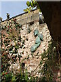
Sculpture at Meanwhile Gardens
This is a close up of the sculpture seen at https://www.geograph.org.uk/photo/7133744 I find it somewhat disturbing.
Meanwhile Gardens is a community garden, established in 1976 between the Grand Union Canal and the brutalist Trelick Tower which looms over it. It has been threatened with development for many years but still survives.
The history of Meanwhile Gardens can be seen at https://meanwhile-gardens.org.uk/history/16
Image: © Marathon
Taken: 28 Mar 2022
0.04 miles