IMAGES TAKEN NEAR TO
Hazlewood Crescent, LONDON, W10 5DX
Introduction
This page details the photographs taken nearby to Hazlewood Crescent, W10 5DX by members of the Geograph project.
The Geograph project started in 2005 with the aim of publishing, organising and preserving representative images for every square kilometre of Great Britain, Ireland and the Isle of Man.

There are currently over 7.5m images from over14,400 individuals and you can help contribute to the project by visiting https://www.geograph.org.uk
Image Map
Images are licensed for reuse under creativecommons.org/licenses/by-sa/2.0
Notes
- Clicking on the map will re-center to the selected point.
- The higher the marker number, the further away the image location is from the centre of the postcode.
Image Listing (340 Images Found)
Images are licensed for reuse under creativecommons.org/licenses/by-sa/2.0
Image
Details
Distance
2
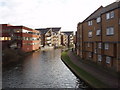
Flats by the Grand Union Canal
The flats on the left are between the canal and Harrow Road, those on the right are on Kensal Road. Photo from footbridge opposite Second Avenue.
Image: © David Hawgood
Taken: 4 Jan 2007
0.03 miles
3
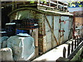
Wagon body
An old railway wagon body in use as a storage facility.
Image: © Oxyman
Taken: 23 May 2007
0.03 miles
4
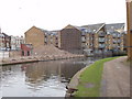
Demolition site by the Grand Union Canal
In the last month or so a red brick building which was on the left of the canal has been demolished. See Image for the building in use in January 2007.
Image: © David Hawgood
Taken: 28 Nov 2007
0.03 miles
5
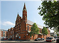
Our Lady of the Holy Souls, Kensal Town
Image: © John Salmon
Taken: 27 Apr 2010
0.03 miles
6
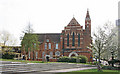
Our Lady of the Holy Souls, Kensal Town
Image: © John Salmon
Taken: 27 Apr 2010
0.03 miles
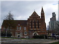
7
Our Lady of the Holy Souls, Kensal Town
Image: © John Salmon
Taken: 27 Apr 2010
0.04 miles
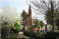
8
Our Lady of the Holy Souls, Kensal New Town
Roman Catholic church built 1881. The local population included a large number of Irish immigrants.
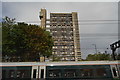
The steps in the foreground lead down into the public recreation area of Emslie Horniman Pleasance. Behind, Trellick Tower.
Image: © Natasha Ceridwen de Chroustchoff
Taken: 14 Mar 2010
0.04 miles
9
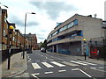
Kensal Road, Kensal Town
Kensal Road at Kensal Town in inner north west London.
Image: © Malc McDonald
Taken: 29 Aug 2015
0.05 miles
10
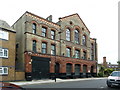
Cobden Working Men's Club and Institute, Kensal Road
Image: © Alexander P Kapp
Taken: 17 Jul 2012
0.05 miles