IMAGES TAKEN NEAR TO
Sunbeam Crescent, LONDON, W10 5DW
Introduction
This page details the photographs taken nearby to Sunbeam Crescent, W10 5DW by members of the Geograph project.
The Geograph project started in 2005 with the aim of publishing, organising and preserving representative images for every square kilometre of Great Britain, Ireland and the Isle of Man.

There are currently over 7.5m images from over14,400 individuals and you can help contribute to the project by visiting https://www.geograph.org.uk
Image Map
Images are licensed for reuse under creativecommons.org/licenses/by-sa/2.0
Notes
- Clicking on the map will re-center to the selected point.
- The higher the marker number, the further away the image location is from the centre of the postcode.
Image Listing (153 Images Found)
Images are licensed for reuse under creativecommons.org/licenses/by-sa/2.0
Image
Details
Distance
1
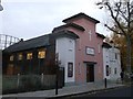
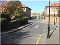
St Francis Community Church
On Dalgarno Gardens (road).
Image: © David Anstiss
Taken: 6 Dec 2013
0.05 miles
2
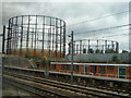
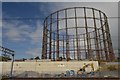
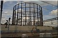
Kensal Gas Works
Nestling in between the Grand Union Canal and the Great Western Railway.
Image: © Claire Ward
Taken: 10 Jun 2005
0.07 miles
3
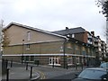
The Dalgarno Trust Community Centre
On the junction of Webb Close and Dalgarno Gardens (on the right).
Image: © David Anstiss
Taken: 6 Dec 2013
0.09 miles
4
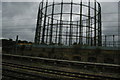
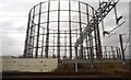
Gasometer from the train, Kensal Green
Image: © Christopher Hilton
Taken: 22 Jun 2013
0.12 miles
10
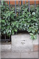
Benchmark on wall of Ladbroke Hall, Barlby Road
Ordnance Survey cut mark benchmark described on the Bench Mark Database at http://www.bench-marks.org.uk/bm38117
Image: © Roger Templeman
Taken: 27 May 2011
0.13 miles