IMAGES TAKEN NEAR TO
Kensal Road, LONDON, W10 5BZ
Introduction
This page details the photographs taken nearby to Kensal Road, W10 5BZ by members of the Geograph project.
The Geograph project started in 2005 with the aim of publishing, organising and preserving representative images for every square kilometre of Great Britain, Ireland and the Isle of Man.

There are currently over 7.5m images from over14,400 individuals and you can help contribute to the project by visiting https://www.geograph.org.uk
Image Map
Images are licensed for reuse under creativecommons.org/licenses/by-sa/2.0
Notes
- Clicking on the map will re-center to the selected point.
- The higher the marker number, the further away the image location is from the centre of the postcode.
Image Listing (337 Images Found)
Images are licensed for reuse under creativecommons.org/licenses/by-sa/2.0
Image
Details
Distance
1
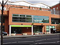
Kensal Road JobCentre Plus office
New offices. For JobCentre Plus organisation, part of the government Department for Work and Pensions, see http://www.jobcentreplus.gov.uk/JCP/Aboutus/index.html.
Image: © David Hawgood
Taken: 26 Feb 2007
0.02 miles
3
The Flora in Harrow Road
Pub that backs on to the canal (literally) with garden presumably accessible for waterborne visitors.
Image: © Natasha Ceridwen de Chroustchoff
Taken: 14 Mar 2010
0.02 miles
4
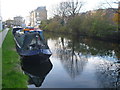
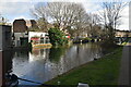
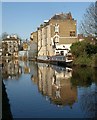
Paddington Arm of the Grand Union Canal
The Paddington Arm of the then Grand Junction Canal was opened in 1801 from Bull's Bridge near Southall to Paddington Basin. The canals were initially a success, particularly for transporting coal, building materials and other bulky loads, but the rise of the railways not long after the canals were built substantially reduced their importance. Now they are primarily a leisure facility. The Paddington Arm was one of the last to see the old-fashioned style of regular commercial traffic of paired narrow boats carrying the traditional materials such as coal, oils, and tar. The Paddington Arm now sees regular commercial traffic, usually in the form of aggregates. What was then the Central Electricity Generating Board laid cables under some of the towpaths in the 1970s, as seen here, and made them suitable for pedestrians again.
The towpath is followed by the Grand Union Canal Walk. This section is between Great Western Road and Ladbroke Grove. The houses on the opposite side are on Harrow Road. Ladbroke Grove is just ahead.
Image: © Marathon
Taken: 4 Dec 2013
0.02 miles
7
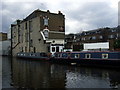
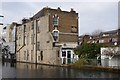
Buildings by the Harrow Road
The modern number 527-533 Harrow Road, a rather distinctive family dwelling, is also shown in Image http://www.l-kahn.co.uk/history.html shows the building, then a cosmetics factory but earlier a rifle factory, on the Harrow road, that previously occupied the site. Beyond is The Flora pub.
Image: © Derek Harper
Taken: 19 Mar 2012
0.03 miles
8
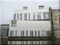
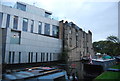
Metallic building next to the Flora pub, Harrow Road
Offices or housing? Difficult to tell. The 'first floor' wall hides a small courtyard. Seen from the towpath of the Grand Union Canal's Paddington Branch.
Image: © Christine Johnstone
Taken: 28 Feb 2012
0.03 miles
9
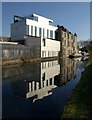
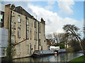
Grand Union Canal, West Kilburn
Similar to Image; see also Image The Flora has a couple of narrowboats moored outside. The white office building on the left is shown in Image
Image: © Derek Harper
Taken: 19 Mar 2012
0.03 miles
10
The Flora, Harrow Road W10
Not immediately recognizable as a pub from the canal side. It looks a good deal smarter from the road.
Image: © Robin Webster
Taken: 12 Feb 2011
0.03 miles