IMAGES TAKEN NEAR TO
St. Johns Terrace, LONDON, W10 4SB
Introduction
This page details the photographs taken nearby to St. Johns Terrace, W10 4SB by members of the Geograph project.
The Geograph project started in 2005 with the aim of publishing, organising and preserving representative images for every square kilometre of Great Britain, Ireland and the Isle of Man.

There are currently over 7.5m images from over14,400 individuals and you can help contribute to the project by visiting https://www.geograph.org.uk
Image Map
Images are licensed for reuse under creativecommons.org/licenses/by-sa/2.0
Notes
- Clicking on the map will re-center to the selected point.
- The higher the marker number, the further away the image location is from the centre of the postcode.
Image Listing (289 Images Found)
Images are licensed for reuse under creativecommons.org/licenses/by-sa/2.0
Image
Details
Distance
1
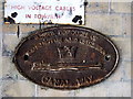
Canal Way street sign, Ladbroke Grove
Canal Way is a short cul-de-sac running between the gas works and the bridge that carries Ladbroke Grove over the canal, and is now the site of a large supermarket. Canal Way may have had more importance formerly as access to the gas works: the sign seems to show a canal boat, perhaps carrying coal, drawn up by the bank.
Image: © Natasha Ceridwen de Chroustchoff
Taken: 14 Mar 2010
0.02 miles
2
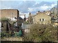
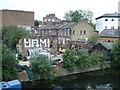
St. John's Terrace, W10
Looking down the dead-end road with the twin towers of St. John's Church just visible on the other side of Harrow Road.
Image: © Robin Webster
Taken: 12 Feb 2011
0.02 miles
3
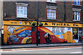
Tyre and Wheel Co. Harrow Road
A very artistic frontage to this workshop on Harrow Road.
The three doors incorporated in the painting have street numbers, letter boxes and bell pushes or door knockers so presumably they are still the access for the flats upstairs?
Also, and you'll have to take my word for it on this size picture, if you zoom onto the paper below the three faces, it says
"Diploma.
Whats My Line
Noreen Hannington beat the panel on Sunday 5th May 1985"
What's my Line was a TV show where you had to guess people's jobs. Presumably they didn't guess Noreen's.
Tyres and Wheels and Panel Beating.
All under one roof.
Image: © Des Blenkinsopp
Taken: 7 Apr 2014
0.02 miles
4
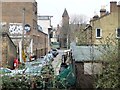
St John's Street, off Harrow Road
Seen from the raised towpath of the Grand Union Canal's Paddington Branch.
Image: © Christine Johnstone
Taken: 28 Feb 2012
0.02 miles
5
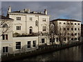
Kensal House, offices by the Grand Union Canal
These pleasant buildings are set back from the Harrow Road. Photo from canal towpath by Ladbroke Grove. The Italianate villa was built by 1835. In 2003 Virgin Records sold this and Portobello Dock to, and leased them back from, Derwent Valley Holdings. Their website http://www.derwentvalley.co.uk/LATEST_NEWS/151203/151203.htm says:
"The waterfront complex, which comprises five office buildings totalling approximately 49,338 ft2 (4,584 m2) with 105 surface car parking spaces, is situated on two sites on either side of the Grand Union Canal. They are linked by a footbridge and together total 1.8 acres."
Image: © David Hawgood
Taken: 4 Jan 2007
0.03 miles
6
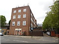
Kensal Green Telephone Exchange (2)
Located at 742 Harrow Road (A404), this TE has the Royal coat of arms carved above its front entrance and a KX100 Plus telephone box to its right. The parking area for the BT Openreach vans can be seen to the right of the photo. This TE now has 0208-960,964,968 and 969 xxxx numbers plus some other Outer London numbers, and its postcode is W10 4NB.
Image: © David Hillas
Taken: 21 May 2016
0.03 miles
7
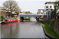
Ladbroke Grove Bridge 4, Paddington Arm, Grand Union Canal
Looking east. Ladbroke Grove is a busy urban road, running north from Kensington to Kensal Green.
Image: © Dr Neil Clifton
Taken: 3 May 2008
0.03 miles
8
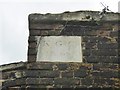
Old Boundary Marker by the B450, Ladbroke Grove, Kensington parish
Estate Boundary Marker - Kensall Green Cemetery by the B450, in parish of Kensington (Kensington and Chelsea District), Ladbroke Grove W10, Northeast boundary wall high up.
Surveyed
Milestone Society National ID: MX_KGC01em
Image: © Milestone Society
Taken: Unknown
0.03 miles
9
Builder's yard, West Kilburn
The area is squeezed between roads, houses and the Grand Union Canal
Image: © David Smith
Taken: 21 May 2011
0.03 miles
10
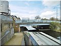
Kensal Green, Bridge No 4
Carrying Ladbroke Grove over Grand Union Canal (Paddington Branch).
Image: © Mike Faherty
Taken: 9 Apr 2016
0.04 miles