IMAGES TAKEN NEAR TO
Harrow Road, LONDON, W10 4RG
Introduction
This page details the photographs taken nearby to Harrow Road, W10 4RG by members of the Geograph project.
The Geograph project started in 2005 with the aim of publishing, organising and preserving representative images for every square kilometre of Great Britain, Ireland and the Isle of Man.

There are currently over 7.5m images from over14,400 individuals and you can help contribute to the project by visiting https://www.geograph.org.uk
Image Map
Images are licensed for reuse under creativecommons.org/licenses/by-sa/2.0
Notes
- Clicking on the map will re-center to the selected point.
- The higher the marker number, the further away the image location is from the centre of the postcode.
Image Listing (290 Images Found)
Images are licensed for reuse under creativecommons.org/licenses/by-sa/2.0
Image
Details
Distance
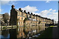
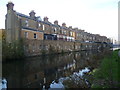
2
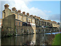
Harrow Road houses from the back
Ramshackle Victorian three-storey terraced houses face Harrow Road with their backs turned to the canal - today the order of priorities might be different now that the waterway is no longer an industrial transport corridor.
Image: © Natasha Ceridwen de Chroustchoff
Taken: 14 Mar 2010
0.01 miles
3
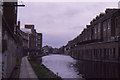
Grand Union Canal, Kensal Town, 1988
To the right, the backs of houses on the Harrow Road. In the distance The Flora pub can just be made out. The factories to the left include, I believe, some subsequently demolished.
Image: © Christopher Hilton
Taken: 7 Feb 1988
0.01 miles
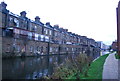
4
Houses by the Grand Union Canal, Paddington arm
Rather a dreary stretch of the canal, seen in dreary November weather. Much of the canalside between here and Paddington has been redeveloped in the last half-century, but before about 1950 much of it must have looked somewhat like this.
The houses face the Harrow Road, which at this point runs close to and parallel with the canal,
Image: © Stefan Czapski
Taken: 5 Nov 2021
0.01 miles
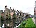
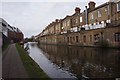
5
Houses along the Paddington Branch of the Grand Union Canal
The Paddington Arm of the then Grand Junction Canal was opened in 1801 from Bull's Bridge near Southall to Paddington Basin. The canals were initially a success, particularly for transporting coal, building materials and other bulky loads, but the rise of the railways not long after the canals were built substantially reduced their importance. Now they are primarily a leisure facility. The Paddington Arm was one of the last to see the old-fashioned style of regular commercial traffic of paired narrow boats carrying the traditional materials such as coal, oils, and tar. The Paddington Arm now sees regular commercial traffic, usually in the form of aggregates. What was then the Central Electricity Generating Board laid cables under some of the towpaths in the 1970s and made them suitable for pedestrians again.
The towpath is followed by the Grand Union Canal Walk. This section is between Ladbroke Grove and Great Western Road. The houses on the opposite side are on Harrow Road. Street View shows that on the Harrow Road side they were shops but only a few still are, many of them having been converted into housing.
Image: © Marathon
Taken: 4 Dec 2013
0.01 miles
8
Avenue Gardens Estate
Council estate in West London, view from the Harrow Road
Image: © Zoe Ryan
Taken: 9 Apr 2011
0.02 miles
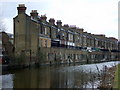
9
431 - 487 (odds) Harrow Road, W10
A long and shallow terrace between road and canal, with shops at ground level, many now converted to other uses.
Image: © Robin Webster
Taken: 12 Feb 2011
0.02 miles
10
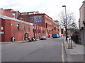
Warehouse converted to offices, Kensal Road
Image: © David Hawgood
Taken: 26 Feb 2007
0.02 miles