IMAGES TAKEN NEAR TO
Fourth Avenue, LONDON, W10 4QT
Introduction
This page details the photographs taken nearby to Fourth Avenue, W10 4QT by members of the Geograph project.
The Geograph project started in 2005 with the aim of publishing, organising and preserving representative images for every square kilometre of Great Britain, Ireland and the Isle of Man.

There are currently over 7.5m images from over14,400 individuals and you can help contribute to the project by visiting https://www.geograph.org.uk
Image Map
Images are licensed for reuse under creativecommons.org/licenses/by-sa/2.0
Notes
- Clicking on the map will re-center to the selected point.
- The higher the marker number, the further away the image location is from the centre of the postcode.
Image Listing (252 Images Found)
Images are licensed for reuse under creativecommons.org/licenses/by-sa/2.0
Image
Details
Distance
1
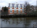
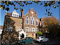
Four geese and a library
Queen's Park Library is at 666 Harrow Road between Fourth and Fifth Avenues and backs on to the canal.
Image: © Natasha Ceridwen de Chroustchoff
Taken: 14 Mar 2010
0.07 miles
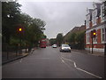
2
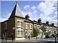
Droop Street, W10
This is Droop Street.
As featured on "Funny British Street Names" http://www.thecareerbreaksite.com/funny-british-street-names.
and no doubt other sites.
At least it's in London, not Swindon or Salisbury.
Droop Street, Wilts, would be too bad....
Image: © Des Blenkinsopp
Taken: 7 Apr 2014
0.08 miles
3
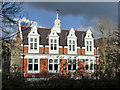
Public library, Harrow Road, W10
Looking across from the canal towpath. Canal and road are separated by a narrow shrubbery with path, called 'Harrow Road Open Space'. This must be one of the smallest open spaces about.
Image: © Robin Webster
Taken: 12 Feb 2011
0.08 miles
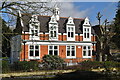
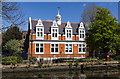
5
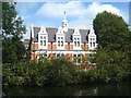
Queens Park Public Library, Harrow Road
This library, designed by the architects Karslake and Mortimer, was opened in 1890, on the corner of Harrow Road and Fourth Avenue. It was Paddington's only Public Library until 1923 when a small library was finally opened in Hatherly Grove. It is seen here from the towpath of the Grand Union Canal.
Image: © Rod Allday
Taken: 3 Sep 2011
0.08 miles
6
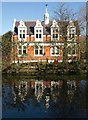
Queens Park Public Library
This maybe doesn't add a lot to the images at http://www.geograph.org.uk/search.php?i=29722877 , but the reflection in the Grand Union Canal appealed to me.
Image: © Derek Harper
Taken: 19 Mar 2012
0.08 miles
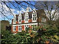
8
Queen's Park Library
Looking north across the Grand Union Canal towards the library at 666 Harrow Road.
Image: © David P Howard
Taken: 13 Apr 2014
0.08 miles
9
Pvblic Library
Several Geographs of this already, unsurprisingly for quite an attractive building.
Late Victorian, which probably accounts for the mock Latin "pvblic" on the front.
Supposed to add "gravitas" (real Latin?) I guess. The Victorians were keen on that sort of thing.
Image: © Des Blenkinsopp
Taken: 7 Apr 2014
0.08 miles