IMAGES TAKEN NEAR TO
Droop Street, LONDON, W10 4DQ
Introduction
This page details the photographs taken nearby to Droop Street, W10 4DQ by members of the Geograph project.
The Geograph project started in 2005 with the aim of publishing, organising and preserving representative images for every square kilometre of Great Britain, Ireland and the Isle of Man.

There are currently over 7.5m images from over14,400 individuals and you can help contribute to the project by visiting https://www.geograph.org.uk
Image Map
Images are licensed for reuse under creativecommons.org/licenses/by-sa/2.0
Notes
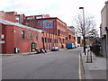
- Clicking on the map will re-center to the selected point.
- The higher the marker number, the further away the image location is from the centre of the postcode.
Image Listing (254 Images Found)
Images are licensed for reuse under creativecommons.org/licenses/by-sa/2.0
Image
Details
Distance
2
Avenue Gardens Estate
Council estate in West London, view from the Harrow Road
Image: © Zoe Ryan
Taken: 9 Apr 2011
0.05 miles
3
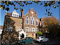
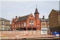
Queen's Park Primary School from Third Avenue
Image: © Dave Kelly
Taken: 15 Nov 2013
0.05 miles
4
Harrow Road houses from the back
Ramshackle Victorian three-storey terraced houses face Harrow Road with their backs turned to the canal - today the order of priorities might be different now that the waterway is no longer an industrial transport corridor.
Image: © Natasha Ceridwen de Chroustchoff
Taken: 14 Mar 2010
0.05 miles
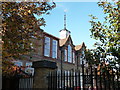
5
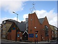
Congregational Hall, Harrow Road, London
Whether this is still in use for religious purpose I do not know, but this photograph will obviously not be available for long as building will be taking place on the vacant plot opposite the camera.
Image: © Dr Neil Clifton
Taken: 3 May 2008
0.06 miles
7
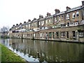
Shops and houses along the Harrow Road
Shops on the ground floor, with houses and back yards on the two floors above. Not sure how anyone gets to the canoe. Seen from the towpath of the Grand Union Canal's Paddington Branch.
Image: © Christine Johnstone
Taken: 28 Feb 2012
0.06 miles
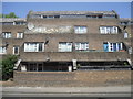
9
Warehouse converted to offices, Kensal Road
Image: © David Hawgood
Taken: 26 Feb 2007
0.06 miles
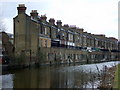
10
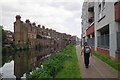
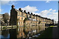
Harrow Road Homes
The Victorian houses on the far bank of the canal are in Harrow Road
Image: © Glyn Baker
Taken: 16 May 2014
0.06 miles