IMAGES TAKEN NEAR TO
Kilburn Lane, LONDON, W10 4BW
Introduction
This page details the photographs taken nearby to Kilburn Lane, W10 4BW by members of the Geograph project.
The Geograph project started in 2005 with the aim of publishing, organising and preserving representative images for every square kilometre of Great Britain, Ireland and the Isle of Man.

There are currently over 7.5m images from over14,400 individuals and you can help contribute to the project by visiting https://www.geograph.org.uk
Image Map
Images are licensed for reuse under creativecommons.org/licenses/by-sa/2.0
Notes
- Clicking on the map will re-center to the selected point.
- The higher the marker number, the further away the image location is from the centre of the postcode.
Image Listing (126 Images Found)
Images are licensed for reuse under creativecommons.org/licenses/by-sa/2.0
Image
Details
Distance
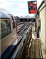
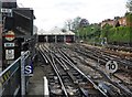
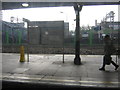
1

Queen's Park railway station
The station serves both the Bakerloo Line and London Overground trains. The original Baker Street and Waterloo Railway (hence Bakerloo) opened in 1906 to Baker Street and was extended here to Queen's Park in 1915. The service was then extended to Watford Junction, only to be subsequently terminated. Since 1989 Bakerloo Line trains have run northwards as far as Harrow and Wealdstone station. Here a southbound Bakerloo Line train is about to depart for Elephant & Castle. By a quirk of the geometry of the railway line, and demonstrating the schematic nature of the classic Underground map, northbound Bakerloo Line trains leaving Queen's Park for Kensal Green actually travel more southwards than northwards, whereas the map shows the line heading due north.
Image: © Nigel Cox
Taken: 26 Nov 2007
0.04 miles
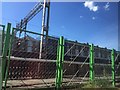
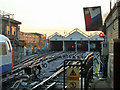
3
Carriage shed bays 21-24 viewed from Queen's Park station
Viewed from a platform looking towards the carriage shed on the west side of the station.
There is a larger carriage shed on the east side.
Image: © Jaggery
Taken: 13 May 2012
0.05 miles
5
Carriage Sheds, London Underground, Queen's Park
Image: © Roger Cornfoot
Taken: 9 May 2015
0.07 miles
6
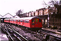
Tube train at Queen's Park
London Underground's Bakerloo line emerges above ground at Queen's Park. Just beyond the station are train sheds. Trains terminating at Queen's Park go into the sheds while trains running to or from destinations further north pass through the sheds.
In this image a train of "1938" stock leaves the sheds for its journey beneath London's streets to Elephant & Castle.
Image: © Malc McDonald
Taken: 31 Mar 1985
0.07 miles
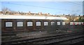
7
Car sheds, Queens Park station
Why are the roads numbered 21 to 24? There are more sheds on the east side of the station, but the total number of roads is nowhere near this number. Where are the low numbered lines?
Image: © Robin Webster
Taken: 19 Mar 2011
0.08 miles
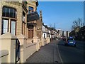
8
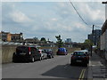
Claremont Road, with Queen's Park Station beyond wall to the left
Image: © Andrew Wilson
Taken: 25 May 2013
0.08 miles
9
Queen's Park station, Bakerloo Line
Image: © Christopher Hilton
Taken: 2 Mar 2012
0.09 miles