IMAGES TAKEN NEAR TO
Jackets Lane, UXBRIDGE, UB9 6PZ
Introduction
This page details the photographs taken nearby to Jackets Lane, UB9 6PZ by members of the Geograph project.
The Geograph project started in 2005 with the aim of publishing, organising and preserving representative images for every square kilometre of Great Britain, Ireland and the Isle of Man.

There are currently over 7.5m images from over14,400 individuals and you can help contribute to the project by visiting https://www.geograph.org.uk
Image Map
Images are licensed for reuse under creativecommons.org/licenses/by-sa/2.0
Notes
- Clicking on the map will re-center to the selected point.
- The higher the marker number, the further away the image location is from the centre of the postcode.
Image Listing (12 Images Found)
Images are licensed for reuse under creativecommons.org/licenses/by-sa/2.0
Image
Details
Distance
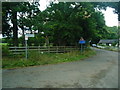
1
Hertfordshire/Greater London boundary, near Harefield
A sign to the left of the road indicates that the road enters the London Borough of Hillingdon. As it does so, it crosses the boundary from Hertfordshire into Greater London.
Image: © Malc McDonald
Taken: 8 Sep 2013
0.03 miles
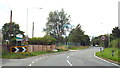
2
Entering Harefield and London
Entering the London Borough of Hillingdon, from Batchworth in Hertfordshire.
Image: © David Howard
Taken: 2 Nov 2011
0.04 miles
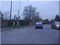
3
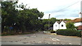
Northwood Road, Harefield
This is the London-Hertfordshire border, entering Harefield from Batchworth.
Image: © David Howard
Taken: 2 Nov 2011
0.04 miles
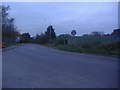
4
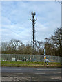
Telecommunications mast, White Hill
The fence is principally for covered reservoirs, off to the left.
Image: © Robin Webster
Taken: 25 Jan 2015
0.06 miles
5
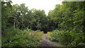
Bishop's Wood Country Park, near Northwood
A muddy path through Bishop's Wood Country Park.
Image: © Malc McDonald
Taken: 8 Sep 2013
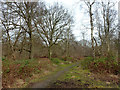
0.08 miles
7
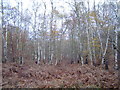
Rickmansworth: Bishop's Wood Country Park
Silver birch woodland in this publicly accessible Country Park managed by Three Rivers District Council.
Image: © Nigel Cox
Taken: 3 Dec 2005
0.14 miles
8

Rickmansworth: Bishop's Wood Country Park
Fine deciduous woodland in this publicly accessible Country Park managed by Three Rivers District Council.
Image: © Nigel Cox
Taken: 3 Dec 2005
0.14 miles
9
Path, Bishop's Wood Country Park
The surfaces of principal paths and the car park here are undergoing improvements, but nothing has happened in this area yet.
Image: © Robin Webster
Taken: 25 Jan 2015
0.15 miles