IMAGES TAKEN NEAR TO
Plough Lane, UXBRIDGE, UB9 6PF
Introduction
This page details the photographs taken nearby to Plough Lane, UB9 6PF by members of the Geograph project.
The Geograph project started in 2005 with the aim of publishing, organising and preserving representative images for every square kilometre of Great Britain, Ireland and the Isle of Man.

There are currently over 7.5m images from over14,400 individuals and you can help contribute to the project by visiting https://www.geograph.org.uk
Image Map
Images are licensed for reuse under creativecommons.org/licenses/by-sa/2.0
Notes
- Clicking on the map will re-center to the selected point.
- The higher the marker number, the further away the image location is from the centre of the postcode.
Image Listing (33 Images Found)
Images are licensed for reuse under creativecommons.org/licenses/by-sa/2.0
Image
Details
Distance
10
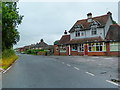
Children in the Pub
A former pub, now the Childlink Learning Centre. Out of shot to the left and getting grown over with bushes is the old pub signpost, minus sign but with an old type metal plough mounted below where the sign would have been. So I'm guessing this was "The Plough"
Image: © Des Blenkinsopp
Taken: 23 Jul 2012
0.06 miles