IMAGES TAKEN NEAR TO
Anderson Close, UXBRIDGE, UB9 6HF
Introduction
This page details the photographs taken nearby to Anderson Close, UB9 6HF by members of the Geograph project.
The Geograph project started in 2005 with the aim of publishing, organising and preserving representative images for every square kilometre of Great Britain, Ireland and the Isle of Man.

There are currently over 7.5m images from over14,400 individuals and you can help contribute to the project by visiting https://www.geograph.org.uk
Image Map
Images are licensed for reuse under creativecommons.org/licenses/by-sa/2.0
Notes
- Clicking on the map will re-center to the selected point.
- The higher the marker number, the further away the image location is from the centre of the postcode.
Image Listing (74 Images Found)
Images are licensed for reuse under creativecommons.org/licenses/by-sa/2.0
Image
Details
Distance
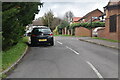
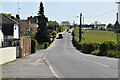
5
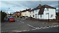
Mount Pleasant, Harefield
Housing in the village of Harefield, on the edge of North West London.
Image: © Malc McDonald
Taken: 8 Sep 2013
0.06 miles
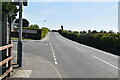
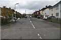
6
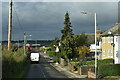
Descending Park Lane at Mount Pleasant
A morning of bright sunlight, strong winds and heavy showers.
Image: © David Martin
Taken: 2 Nov 2020
0.07 miles