IMAGES TAKEN NEAR TO
Broadwater Lane, UXBRIDGE, UB9 6AQ
Introduction
This page details the photographs taken nearby to Broadwater Lane, UB9 6AQ by members of the Geograph project.
The Geograph project started in 2005 with the aim of publishing, organising and preserving representative images for every square kilometre of Great Britain, Ireland and the Isle of Man.

There are currently over 7.5m images from over14,400 individuals and you can help contribute to the project by visiting https://www.geograph.org.uk
Image Map
Images are licensed for reuse under creativecommons.org/licenses/by-sa/2.0
Notes
- Clicking on the map will re-center to the selected point.
- The higher the marker number, the further away the image location is from the centre of the postcode.
Image Listing (151 Images Found)
Images are licensed for reuse under creativecommons.org/licenses/by-sa/2.0
Image
Details
Distance
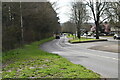
2
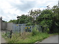
Electrical substation in Broadwater Lane
Image: © Rod Allday
Taken: 26 Jun 2016
0.11 miles
3
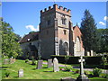
Harefield: Church of St Mary the Virgin
The church is in Countess Close, off Church Hill. The churchyard contains a large number of graves of Australian soldiers who died of their wounds at the hospital at Harefield Park during the First World War.
Image: © Nigel Cox
Taken: 6 Aug 2007
0.12 miles
4

Mayling Transport depot at Broadwater Farm
Image: © Rod Allday
Taken: 26 Jun 2016
0.13 miles
6
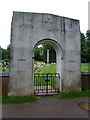
Memorial Arch, Australian Military Cemetery, Harefield Parish Graveyard
Image: © Alexander P Kapp
Taken: 16 Jul 2012
0.14 miles
7

St Mary the Virgin, Harefield, Noticeboard
Image: © Alexander P Kapp
Taken: 16 Jul 2012
0.14 miles
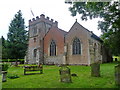
9

Harefield Parish Church, from the south-west
Photo taken from the south-west corner of the old churchyard, in a brief sunny spell on a January afternoon. The church has both north and south aisles, the north aisle being attached to the tower. A more recent cemetery extends southwards.
The site is reached down a dead-end road, and lies in a secluded hollow, out of sight of the main road.
Image: © Stefan Czapski
Taken: 22 Jan 2014
0.15 miles