IMAGES TAKEN NEAR TO
Woodhurst Drive, UXBRIDGE, UB9 5LL
Introduction
This page details the photographs taken nearby to Woodhurst Drive, UB9 5LL by members of the Geograph project.
The Geograph project started in 2005 with the aim of publishing, organising and preserving representative images for every square kilometre of Great Britain, Ireland and the Isle of Man.

There are currently over 7.5m images from over14,400 individuals and you can help contribute to the project by visiting https://www.geograph.org.uk
Image Map
Images are licensed for reuse under creativecommons.org/licenses/by-sa/2.0
Notes
- Clicking on the map will re-center to the selected point.
- The higher the marker number, the further away the image location is from the centre of the postcode.
Image Listing (14 Images Found)
Images are licensed for reuse under creativecommons.org/licenses/by-sa/2.0
Image
Details
Distance
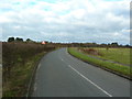
5
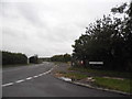
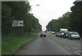
Denham Green Lane at the junction of Tilehouse Lane
Image: © David Howard
Taken: 26 Aug 2014
0.16 miles
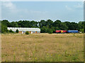
6
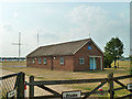
2370 (Denham) Squadron, Air Training Corps
The building is in a compound at the edge of Denham Aerodrome.
Image: © Robin Webster
Taken: 17 Jul 2013
0.19 miles
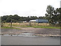
7
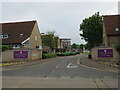
Junction of Queen Mother's Drive with Denham Green Lane
Queen Mother's Drive leads to Denham Garden Village, a retirement housing complex built in 1955 and refurbished in 2006.
Image: © Richard Rogerson
Taken: 3 Jun 2021
0.20 miles

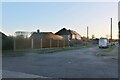
9
Tilehouse Lane east side of Denham Aerodrome
Image: © Alexander P Kapp
Taken: 2 Feb 2013
0.23 miles