IMAGES TAKEN NEAR TO
Slade Oak Lane, UXBRIDGE, UB9 5DP
Introduction
This page details the photographs taken nearby to Slade Oak Lane, UB9 5DP by members of the Geograph project.
The Geograph project started in 2005 with the aim of publishing, organising and preserving representative images for every square kilometre of Great Britain, Ireland and the Isle of Man.

There are currently over 7.5m images from over14,400 individuals and you can help contribute to the project by visiting https://www.geograph.org.uk
Image Map
Images are licensed for reuse under creativecommons.org/licenses/by-sa/2.0
Notes
- Clicking on the map will re-center to the selected point.
- The higher the marker number, the further away the image location is from the centre of the postcode.
Image Listing (42 Images Found)
Images are licensed for reuse under creativecommons.org/licenses/by-sa/2.0
Image
Details
Distance
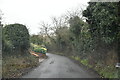
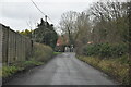
3
Middle Road, Higher Denham
A lot of thought went into naming the streets in the small community of Higher Denham on its hillside site.
Upper, Middle and Lower roads follow the contours of the valley side, while just round the corner from here the steeper Side Road follows the slope.
Image: © Des Blenkinsopp
Taken: 9 Nov 2021
0.06 miles

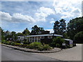
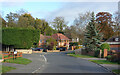
7
Higher Denham Community Hall
On Lower road.
Image: © JThomas
Taken: 13 Apr 2019
0.07 miles
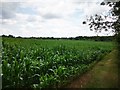
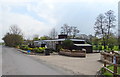
9
Slade Oak Lane at the junction of Lower Road
Image: © David Howard
Taken: 26 Aug 2014
0.07 miles
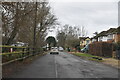
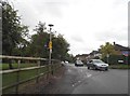
10
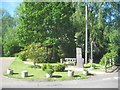
Denham: Higher Denham Millennium slab and seat
The slate slab, inscribed "Higher Denham 2000" and the bench with "2000" carved in the woodwork, are by the Community Centre on Lower Road.
Image: © Nigel Cox
Taken: 24 May 2015
0.07 miles