IMAGES TAKEN NEAR TO
New Windsor Street, UXBRIDGE, UB8 2TU
Introduction
This page details the photographs taken nearby to New Windsor Street, UB8 2TU by members of the Geograph project.
The Geograph project started in 2005 with the aim of publishing, organising and preserving representative images for every square kilometre of Great Britain, Ireland and the Isle of Man.

There are currently over 7.5m images from over14,400 individuals and you can help contribute to the project by visiting https://www.geograph.org.uk
Image Map
Images are licensed for reuse under creativecommons.org/licenses/by-sa/2.0
Notes
- Clicking on the map will re-center to the selected point.
- The higher the marker number, the further away the image location is from the centre of the postcode.
Image Listing (307 Images Found)
Images are licensed for reuse under creativecommons.org/licenses/by-sa/2.0
Image
Details
Distance
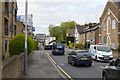
3
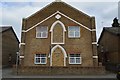
Uxbridge: The Pavilions
A multi-storey car park at The Pavilions shopping mall, viewed from the pedestrian footbridge over the A4020 Oxford Road.
Image: © Nigel Cox
Taken: 21 Jan 2007
0.02 miles
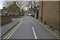
5
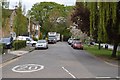
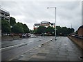
Trumper Way, Uxbridge
This is part of a gyratory system close to Uxbridge town centre where the A4020 meets the A408 and the A4007. Note the attractive flower tubs on the railings.
Image: © Stephen McKay
Taken: 15 Aug 2017
0.04 miles
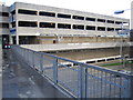
6
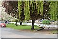
Oxford Road
Main road close Uxbridge town centre.
Image: © James Emmans
Taken: 30 Jul 2019
0.05 miles
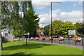
7
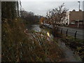
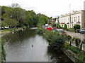
Fray's River, Uxbridge
From the bridge on Rockingham Road
Image: © David Howard
Taken: 30 Nov 2014
0.05 miles