IMAGES TAKEN NEAR TO
Bridge Road, UXBRIDGE, UB8 2QP
Introduction
This page details the photographs taken nearby to Bridge Road, UB8 2QP by members of the Geograph project.
The Geograph project started in 2005 with the aim of publishing, organising and preserving representative images for every square kilometre of Great Britain, Ireland and the Isle of Man.

There are currently over 7.5m images from over14,400 individuals and you can help contribute to the project by visiting https://www.geograph.org.uk
Image Map
Images are licensed for reuse under creativecommons.org/licenses/by-sa/2.0
Notes
- Clicking on the map will re-center to the selected point.
- The higher the marker number, the further away the image location is from the centre of the postcode.
Image Listing (39 Images Found)
Images are licensed for reuse under creativecommons.org/licenses/by-sa/2.0
Image
Details
Distance
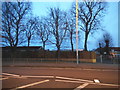
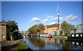
2
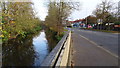
Fray's River and the A408, Cowley Road, Uxbridge
Image: © Rob Emms
Taken: 26 Nov 2016
0.10 miles
3
Fray's River
Running next to Cowley Road
Image: © Ray Stanton
Taken: 20 Jun 2006
0.11 miles
4
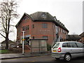
Former Chiltern View Tavern, Uxbridge
This former public house on Cowley Road, which has been boarded-up for many years is now repaired and rebuilt into apartments dwellings.
Image: © Rob Emms
Taken: 26 Nov 2016
0.16 miles
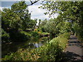
6
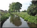
Fray's River in Uxbridge
Frays River is a semi-canalised short river that branches off the River Colne at Uxbridge Moor and rejoins it at West Drayton. The river is believed to be an artificial diversion of waters from the River Colne to feed watermills around Uxbridge. The name originated from John Fray who owned Cowley Hall beside the river in the 15th century. This view is from Iver Lane.
It is seen here from the footbridge over the river which leads from Wellington Road into Rockingham Recreation Ground. The recreation ground can be seen on the right here.
Image: © Marathon
Taken: 22 May 2019
0.18 miles
7

Newsagent in Waterloo Road, Uxbridge
On the afternoon of New Year's Eve the area was very quiet, this shop seemed to be the only sign of life.
Image: © David Hawgood
Taken: 31 Dec 2008
0.19 miles
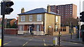
8
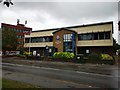
Salvation Army in Cowley Road
Modern purpose built centre.
website : https://www.salvationarmy.org.uk/uxbridge
Image: © James Emmans
Taken: 30 Jul 2019
0.21 miles
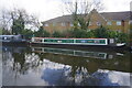
10
London Loop leaves the Canal
Coming southwards, The Loop long distance path has followed the GUC towpath since Harefield, but at this point leaves the canal down the slope on the left to follow the River Colne instead.
Image: © Des Blenkinsopp
Taken: 18 Oct 2011
0.22 miles