IMAGES TAKEN NEAR TO
Linden Terrace, High Road, UXBRIDGE, UB8 2HU
Introduction
This page details the photographs taken nearby to Linden Terrace, High Road, UB8 2HU by members of the Geograph project.
The Geograph project started in 2005 with the aim of publishing, organising and preserving representative images for every square kilometre of Great Britain, Ireland and the Isle of Man.

There are currently over 7.5m images from over14,400 individuals and you can help contribute to the project by visiting https://www.geograph.org.uk
Image Map
Images are licensed for reuse under creativecommons.org/licenses/by-sa/2.0
Notes
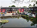
- Clicking on the map will re-center to the selected point.
- The higher the marker number, the further away the image location is from the centre of the postcode.
Image Listing (96 Images Found)
Images are licensed for reuse under creativecommons.org/licenses/by-sa/2.0
Image
Details
Distance
1
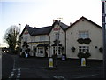
The Paddington Packet Boat Pub, Cowley
High Street, Cowley, Uxbridge, UB8 2HT close to the Grand Union Canal
Image: © canalandriversidepubs co uk
Taken: Unknown
0.02 miles
2
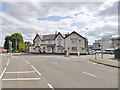
Yiewsley, The Paddington Packet Boat
Fuller's pub with accommodation, at the corner of High Road and Packet Boat Lane. Central bar, eating and drinking on three sides; garden, pool, darts, games machines, TV. Cask ales on offer at my visit: Chiswick, ESB, London Pride. For some customer comments, see http://www.beerintheevening.com/pubs/s/44/4472/Paddington_Packet_Boat/Uxbridge
Image: © Mike Faherty
Taken: 16 Aug 2014
0.02 miles

4
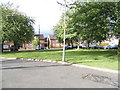
Pinn Close, Cowley Peachey
The River Pinn carries on to Pinner but is a few roads south of this point.
Image: © David Howard
Taken: 11 May 2014
0.07 miles
5
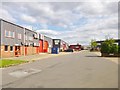
Yiewsley, Tomo Trading Estate
Off Packet Boat Lane.
Image: © Mike Faherty
Taken: 16 Aug 2014
0.09 miles
6
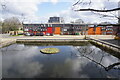
Canal basin and Tomo Industrial Estate
View from canal towpath opposite the Packet Boat Marina
Image: © David Hawgood
Taken: 13 May 2008
0.09 miles
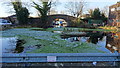
8
Packet Boat Marina
Taken from Packet Boat Lane bridge looking south
Image: © Ray Stanton
Taken: 1 Nov 2005
0.10 miles
9
Unused small marina, off the Grand Union Canal
This is within a warehouse area off Packet Boat Lane. Well maintained and used as a water feature (I'm guessing). The other side of the bridge is the Grand Union Canal.
Image: © Rob Emms
Taken: 29 Nov 2016
0.10 miles
10
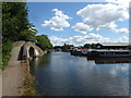
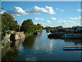
Grand Union Canal at Cowley Peachey
This section of the Grand Union Canal from the River Thames at Brentford was opened in 1794. It was the first section of what was originally called the Grand Junction Canal. Its purpose was to provide a new, shorter and quicker transport route between London and Birmingham by connecting with a network of canals at Braunston near Daventry. When the canal reached Braunston in 1805 it cut 60 miles off the shortest alternative route.
To the east of West Drayton the canal follows the Great Western Main Line but then the canal swings away to the north-west as it heads up to Uxbridge. This is just south of Packet Boat Lane with a marina on the other side of the canal to the right and a typical canal bridge taking the towpath over the entrance to an old dock just ahead. The towpath is followed by the London LOOP.
Image: © Marathon
Taken: 8 Aug 2018
0.10 miles