IMAGES TAKEN NEAR TO
Montague Road, UXBRIDGE, UB8 1QL
Introduction
This page details the photographs taken nearby to Montague Road, UB8 1QL by members of the Geograph project.
The Geograph project started in 2005 with the aim of publishing, organising and preserving representative images for every square kilometre of Great Britain, Ireland and the Isle of Man.

There are currently over 7.5m images from over14,400 individuals and you can help contribute to the project by visiting https://www.geograph.org.uk
Image Map
Images are licensed for reuse under creativecommons.org/licenses/by-sa/2.0
Notes
- Clicking on the map will re-center to the selected point.
- The higher the marker number, the further away the image location is from the centre of the postcode.
Image Listing (194 Images Found)
Images are licensed for reuse under creativecommons.org/licenses/by-sa/2.0
Image
Details
Distance
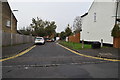
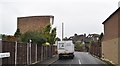
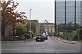
5

Chippendale Waye
No, the last "e" is NOT a typo.
Image: © Mike Quinn
Taken: 5 Jul 2017
0.06 miles

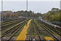
7
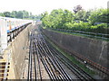
Metropolitan and Piccadilly Line railways at Uxbridge
These are the trackwork arrangements in the cutting at the throat of Uxbridge station, viewed from the York Road bridge. The Image are above the cutting to the left.
Image: © Nigel Cox
Taken: 11 May 2008
0.07 miles
8
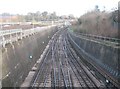
Metropolitan and Piccadilly Line railways at Uxbridge
These are the track arrangements in the cutting showing how the usual two track line expands to a three track line at the approach to Uxbridge Underground Station (and vice versa).
Image: © Nigel Cox
Taken: 11 Jan 2015
0.08 miles