IMAGES TAKEN NEAR TO
Beacon Close, UXBRIDGE, UB8 1PX
Introduction
This page details the photographs taken nearby to Beacon Close, UB8 1PX by members of the Geograph project.
The Geograph project started in 2005 with the aim of publishing, organising and preserving representative images for every square kilometre of Great Britain, Ireland and the Isle of Man.

There are currently over 7.5m images from over14,400 individuals and you can help contribute to the project by visiting https://www.geograph.org.uk
Image Map
Images are licensed for reuse under creativecommons.org/licenses/by-sa/2.0
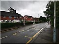
Notes
- Clicking on the map will re-center to the selected point.
- The higher the marker number, the further away the image location is from the centre of the postcode.
Image Listing (24 Images Found)
Images are licensed for reuse under creativecommons.org/licenses/by-sa/2.0
Image
Details
Distance
3
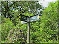
Public footpath sign, Uxbridge Alderglade Nature Reserve
Hillingdon London Borough has a clear set of maps https://hillingdon.gov.uk/article/4908/Definitive-Map-and-Statement showing footpath numbers. U56 runs on the West bank of Fray's River, U58 goes across a footbridge here, down the East bank, and up to Harefield Road.
Image: © David Hawgood
Taken: 7 Jun 2021
0.12 miles
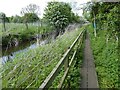
4
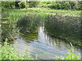
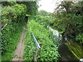
Reeds in Fray's River, Uxbridge
There are public footpaths both sides of the river.
Image: © David Hawgood
Taken: 7 Jun 2021
0.12 miles
5
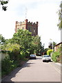
Water Tower, near Uxbridge Common
The road is Water Tower Close. Driving along the A40 I had always thought this was a church tower until I cycled up to it to have a look.
Image: © David Hawgood
Taken: 19 Jun 2005
0.12 miles
6
The Shire Ditch, Uxbridge
To the left is the Shire Ditch and to the right the embankment that once carried the railway out of Uxbridge High Street Station. The path here is made of old railway sleepers and runs through the Alderglade nature reserve.
Image: © Roger Muggleton
Taken: 14 May 2016
0.13 miles
7
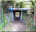
Tunnel under DWR embankment
A tunnel under the embankment that once carried the branch line from the Chiltern line near Denham to Uxbridge High Street Station. The line closed to passengers in 1936 and lingered on until full closure in 1964. The intention was to link the line to Uxbridge Vine Street Station and on to West Drayton and a viaduct over the High Street was partially built. But this never happened and both branch lines have been completely removed.
Image: © Roger Muggleton
Taken: 14 May 2016
0.13 miles
8
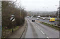
B467 Slip Road
Looking down the slip road towards the A40.
Image: © Martin Addison
Taken: 28 Feb 2015
0.13 miles
9
Shire Ditch and footpath with boardwalk, Uxbridge
Image is a photo of the same area looking the other way.
Image: © David Hawgood
Taken: 7 Jun 2021
0.14 miles
10
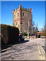
Water tower north of Uxbridge Common
Built in 1906 by the Rickmansworth & Uxbridge Valley Water Company to improve the town's water supply, this has now been converted into flats. Its high location also makes it an ideal site for aerials and mobile phone receivers/transmitters.
Image: © Rod Allday
Taken: 7 Mar 2010
0.14 miles