IMAGES TAKEN NEAR TO
Park Road, UXBRIDGE, UB8 1NU
Introduction
This page details the photographs taken nearby to Park Road, UB8 1NU by members of the Geograph project.
The Geograph project started in 2005 with the aim of publishing, organising and preserving representative images for every square kilometre of Great Britain, Ireland and the Isle of Man.

There are currently over 7.5m images from over14,400 individuals and you can help contribute to the project by visiting https://www.geograph.org.uk
Image Map
Images are licensed for reuse under creativecommons.org/licenses/by-sa/2.0
Notes
- Clicking on the map will re-center to the selected point.
- The higher the marker number, the further away the image location is from the centre of the postcode.
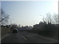
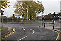
Image Listing (49 Images Found)
Images are licensed for reuse under creativecommons.org/licenses/by-sa/2.0
Image
Details
Distance
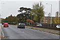
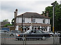
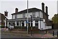
2
Park Road Uxbridge
At junction of Honeycroft Hill
Image: © David Howard
Taken: 8 Mar 2011
0.08 miles

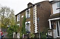
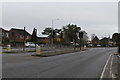
10
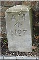
Old Boundary Marker
Air Ministry Boundary Markers against a brick wall at the entrance to the close on the southwest side of the junction of Southside Close and Honeycroft Hill, Uxbridge. Inscribed A M / ↑ / No 7.
Milestone Society National ID: MX_AMUXB07em
Image: © M Bardell
Taken: 2 Jan 2019
0.12 miles