IMAGES TAKEN NEAR TO
Park Road, UXBRIDGE, UB8 1NS
Introduction
This page details the photographs taken nearby to Park Road, UB8 1NS by members of the Geograph project.
The Geograph project started in 2005 with the aim of publishing, organising and preserving representative images for every square kilometre of Great Britain, Ireland and the Isle of Man.

There are currently over 7.5m images from over14,400 individuals and you can help contribute to the project by visiting https://www.geograph.org.uk
Image Map
Images are licensed for reuse under creativecommons.org/licenses/by-sa/2.0
Notes
- Clicking on the map will re-center to the selected point.
- The higher the marker number, the further away the image location is from the centre of the postcode.
Image Listing (28 Images Found)
Images are licensed for reuse under creativecommons.org/licenses/by-sa/2.0
Image
Details
Distance
1
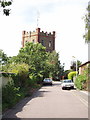
Water Tower, near Uxbridge Common
The road is Water Tower Close. Driving along the A40 I had always thought this was a church tower until I cycled up to it to have a look.
Image: © David Hawgood
Taken: 19 Jun 2005
0.06 miles
4
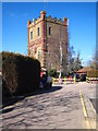
Water tower north of Uxbridge Common
Built in 1906 by the Rickmansworth & Uxbridge Valley Water Company to improve the town's water supply, this has now been converted into flats. Its high location also makes it an ideal site for aerials and mobile phone receivers/transmitters.
Image: © Rod Allday
Taken: 7 Mar 2010
0.09 miles
5
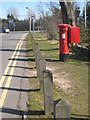
GR post box in North Common Road
On the northern edge of Uxbridge Common.
Image: © Rod Allday
Taken: 7 Mar 2010
0.11 miles
6
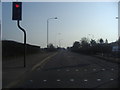
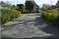
Park Road Uxbridge
At Harefield Road junction
Image: © David Howard
Taken: 8 Mar 2011
0.12 miles
7
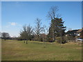
The northern edge of Uxbridge Common
This part of the common includes an area of acid grassland and gorse.
Image: © Rod Allday
Taken: 7 Mar 2010
0.13 miles
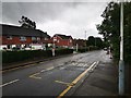
9
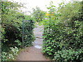
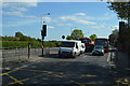
Public footpath entrance from Park Road, B483
This entrance is just by the Uxbridge Cricket Club ground. The path leads to a footbridge over the A40, then on into Ickenham. There is a cycle track immediately outside the gate, the yellow signs warns about it.
Image: © David Hawgood
Taken: 14 Jun 2020
0.15 miles
10
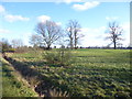
Uxbridge Common
Uxbridge Common is typical of the traditional village common in its layout and includes a pond, a network of ditches and tree planting around the edges, as seen here alongside North Common Road. The pond in the north-west corner is home to Great-Crested Newts - see http://www.geograph.org.uk/photo/5673638
The Common is a fragment of remnant heath, meaning a small area of heathland remaining after the main part, which historically would have covered the surrounding area, no longer exists. There is a larger area on current Ordnance Maps marked as Uxbridge Common to the east, bounded by Park Road, the Metropolitan line and the A40. This can also be seen on Ordnance Maps from the turn of the 20th century, although at that time neither the railway nor the A40 existed here - see http://maps.nls.uk/geo/explore/#zoom=15&lat=51.5533&lon=-0.4743&layers=B000000000TFFFFFFFFFFFFFFFFFFFFFFFFFFFFFFFFFFFFFFFFFFFFFFFFFFFFFFFFFFFFFFFFFFFFFFFFFFFFFFFFFFFFFFFFFFFFFFFFFFFFFFFFFFFFFFFFFFFFFFFFFFFFFFFFFFFFFFFFFFFFFFFFFFFFFFFFFFFFFFFFFFFFFFFFFFFFFFFFFFFFFFFFFFFFFFFFFFFFFFFTFFFFFFFFFFFFFFFFFFFFFFFFFFFFFFFFF
Image: © Marathon
Taken: 7 Feb 2018
0.17 miles