IMAGES TAKEN NEAR TO
Almond Avenue, WEST DRAYTON, UB7 9EJ
Introduction
This page details the photographs taken nearby to Almond Avenue, UB7 9EJ by members of the Geograph project.
The Geograph project started in 2005 with the aim of publishing, organising and preserving representative images for every square kilometre of Great Britain, Ireland and the Isle of Man.

There are currently over 7.5m images from over14,400 individuals and you can help contribute to the project by visiting https://www.geograph.org.uk
Image Map
Images are licensed for reuse under creativecommons.org/licenses/by-sa/2.0
Notes
- Clicking on the map will re-center to the selected point.
- The higher the marker number, the further away the image location is from the centre of the postcode.
Image Listing (7 Images Found)
Images are licensed for reuse under creativecommons.org/licenses/by-sa/2.0
Image
Details
Distance
1
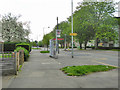
North Road bus stop on Porters Way
Served by route U5 towards West Drayton station.
Image: © Robin Webster
Taken: 22 Apr 2018
0.13 miles
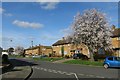
2
Bell Farm Church
Very friendly modern looking web page.
http://www.bfcc.org.uk/welcome.htm
Image: © James Emmans
Taken: 25 Mar 2017
0.15 miles
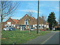
3

Post war housing at West Drayton
Part of the Bell Farm Estate, built on the site of cherry orchards.
Image: © Rod Allday
Taken: 25 Jun 2008
0.15 miles
5

Path
From Bourne Farm Field to Stockley Road looking west
Image: © Ray Stanton
Taken: 27 Oct 2005
0.17 miles
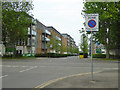
7
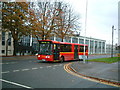
Bus passes RAF West Drayton
Junction of North Road and Porters Way looking north east.
Image: © Ray Stanton
Taken: 10 Nov 2005
0.20 miles