IMAGES TAKEN NEAR TO
Iron Bridge Road, WEST DRAYTON, UB7 8HY
Introduction
This page details the photographs taken nearby to Iron Bridge Road, UB7 8HY by members of the Geograph project.
The Geograph project started in 2005 with the aim of publishing, organising and preserving representative images for every square kilometre of Great Britain, Ireland and the Isle of Man.

There are currently over 7.5m images from over14,400 individuals and you can help contribute to the project by visiting https://www.geograph.org.uk
Image Map
Images are licensed for reuse under creativecommons.org/licenses/by-sa/2.0
Notes
- Clicking on the map will re-center to the selected point.
- The higher the marker number, the further away the image location is from the centre of the postcode.
Image Listing (49 Images Found)
Images are licensed for reuse under creativecommons.org/licenses/by-sa/2.0
Image
Details
Distance
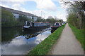
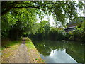
2
Grand Union Canal at Stockley Park
The park is on the left; on the south bank are the Berrite Works.
Image: © Derek Harper
Taken: 20 Sep 2010
0.02 miles
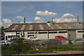
4
Orange Way after Wiltshire (508)
Most, possibly all, of the far bank is in the next grid square to the south.
Image: © Shazz
Taken: 12 Sep 2013
0.03 miles
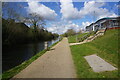
5
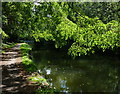
Towpath along the Grand Union Canal
This tree lined stretch of the canal is between bridges 193 and 194a.
Image: © Mat Fascione
Taken: 21 Aug 2015
0.05 miles


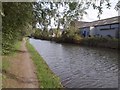
9
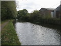
Shakespeare's Way
Shakespeare's Way on the towpath by the Grand Union Canal heading to Hayes
Image: © Shaun Ferguson
Taken: 12 Aug 2014
0.06 miles