IMAGES TAKEN NEAR TO
Tavistock Road, WEST DRAYTON, UB7 7QZ
Introduction
This page details the photographs taken nearby to Tavistock Road, UB7 7QZ by members of the Geograph project.
The Geograph project started in 2005 with the aim of publishing, organising and preserving representative images for every square kilometre of Great Britain, Ireland and the Isle of Man.

There are currently over 7.5m images from over14,400 individuals and you can help contribute to the project by visiting https://www.geograph.org.uk
Image Map
Images are licensed for reuse under creativecommons.org/licenses/by-sa/2.0
Notes
- Clicking on the map will re-center to the selected point.
- The higher the marker number, the further away the image location is from the centre of the postcode.
Image Listing (124 Images Found)
Images are licensed for reuse under creativecommons.org/licenses/by-sa/2.0
Image
Details
Distance
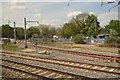
1
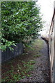
A charter train traverses the Colnbrook Branch
Not much clearance on this freight-only line with trees overhanging the boundary fence. The charter is led by Class 66/0 diesel locomotive number 66200, with classmate number 66213 at the rear.
Image: © Roger Templeman
Taken: 28 Jan 2012
0.05 miles
2
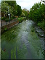
Beeches Way (98)
The route crosses Fray's River which is a tributary of the River Colne.
Image: © Shazz
Taken: 21 May 2013
0.08 miles
3
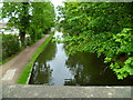
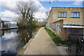
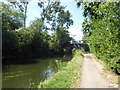
Beeches Way (100)
Here's the Grand Union Canal looking southwards at the end of Beeches Way.
Image: © Shazz
Taken: 21 May 2013
0.10 miles
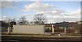
9
Beeches Way (99)
Trout Road ascends to cross the Grand Union Canal at the end of the Beeches Way.
Image: © Shazz
Taken: 21 May 2013
0.12 miles
10
The London LOOP at Yiewsley
This section of the Grand Union Canal from the River Thames at Brentford was opened in 1794. It was the first section of what was originally called the Grand Junction Canal. Its purpose was to provide a new, shorter and quicker transport route between London and Birmingham by connecting with a network of canals at Braunston near Daventry. When the canal reached Braunston in 1805 it cut 60 miles off the shortest alternative route.
To the east of West Drayton the canal follows the Great Western Main Line but here the canal swings away to the north-west as it heads up to Uxbridge. The towpath is followed by the London LOOP.
Image: © Marathon
Taken: 1 Aug 2018
0.12 miles