IMAGES TAKEN NEAR TO
Blunts Avenue, WEST DRAYTON, UB7 0DR
Introduction
This page details the photographs taken nearby to Blunts Avenue, UB7 0DR by members of the Geograph project.
The Geograph project started in 2005 with the aim of publishing, organising and preserving representative images for every square kilometre of Great Britain, Ireland and the Isle of Man.

There are currently over 7.5m images from over14,400 individuals and you can help contribute to the project by visiting https://www.geograph.org.uk
Image Map
Images are licensed for reuse under creativecommons.org/licenses/by-sa/2.0
Notes
- Clicking on the map will re-center to the selected point.
- The higher the marker number, the further away the image location is from the centre of the postcode.
Image Listing (56 Images Found)
Images are licensed for reuse under creativecommons.org/licenses/by-sa/2.0
Image
Details
Distance
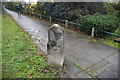
2
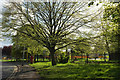
Green by Sipson Way
A lime tree, I think, just bursting into leaf on a bend by the entrance to Sipson Community Centre.
Image: © Derek Harper
Taken: 26 Apr 2018
0.06 miles
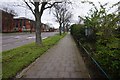
5
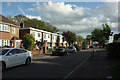
Sipson Way
Looking down the road from where Image] was taken, towards the junction with the A4 Bath Road where a bus is passing.
Image: © Derek Harper
Taken: 26 Apr 2018
0.07 miles
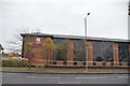
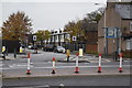
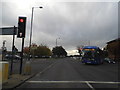
9

A4 at Sipson Way
On a rather horrid morning, by the bus stop just east of the junction. The radar mast is by the West Ramp Coach Park.
Image: © Derek Harper
Taken: 27 Apr 2018
0.07 miles
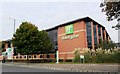
10
Bath Road by Heathrow Airport
The edge of the Holiday Inn Hotel is on the right
Image: © David Howard
Taken: 21 Oct 2013
0.08 miles