IMAGES TAKEN NEAR TO
Meadowlea Close, WEST DRAYTON, UB7 0AF
Introduction
This page details the photographs taken nearby to Meadowlea Close, UB7 0AF by members of the Geograph project.
The Geograph project started in 2005 with the aim of publishing, organising and preserving representative images for every square kilometre of Great Britain, Ireland and the Isle of Man.

There are currently over 7.5m images from over14,400 individuals and you can help contribute to the project by visiting https://www.geograph.org.uk
Image Map
Images are licensed for reuse under creativecommons.org/licenses/by-sa/2.0
Notes
- Clicking on the map will re-center to the selected point.
- The higher the marker number, the further away the image location is from the centre of the postcode.
Image Listing (58 Images Found)
Images are licensed for reuse under creativecommons.org/licenses/by-sa/2.0
Image
Details
Distance
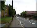
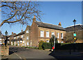
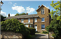
2
An Old Corner, Home Farm
There are still a lot of reminders round this area that before Heathrow Airport and all that were ever thought of, there was rural Middlesex with farms and villages like anywhere else.
These old buildings are part of Home Farm which amazingly still seems to be a working farm within sight (and sound and smell) of the airport.
Image: © Des Blenkinsopp
Taken: 15 Feb 2023
0.05 miles
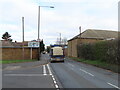
3
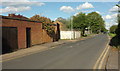
Harmondsworth Lane
This road leads from Harmondsworth to Sipson and runs straight for a kilometre. For the first 300 metres it is lined with houses on the north side; for the rest, it runs through fields north of Heathrow airport.
Image: © Derek Harper
Taken: 26 Apr 2018
0.05 miles
4

Hatch Lane at the junction of High Street Harmondsworth
Image: © David Howard
Taken: 21 Oct 2013
0.06 miles
5
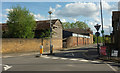
Home Farm, Harmondsworth
Farm buildings by the mini-roundabout at the east end of the High Street. You might just make out a gabled porch on the immediate right, which belongs to Harmondsworth Baptist Church, an attractive building rather more clearly shown in Image
Image: © Derek Harper
Taken: 26 Apr 2018
0.06 miles
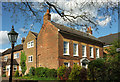
6
Acacia Mews, Harmondsworth
Harmondsworth is an old village that has been surrounded by motorways, airports and 20th century in general, but has still managed to keep a small area from before all that.
Image: © Des Blenkinsopp
Taken: 15 Feb 2023
0.07 miles
7
Acacia House, Harmondsworth
A listed C18 house https://www.historicengland.org.uk/listing/the-list/list-entry/1080199 near the east end of the village.
Image: © Derek Harper
Taken: 26 Apr 2018
0.07 miles
8
Harmondsworth "Village centre only" sign
As shown in Image the road to the left which could give access to an industrial estate is blocked. To the left the sign reads "Village centre only. No access to Saxon Way." To the right "All other traffic. A3044 (A408) (M4)". In the photo on the right are buildings of Home Farm. The side road on the left is Wilton Close.
Image: © David Hawgood
Taken: 20 Feb 2023
0.09 miles
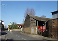
9
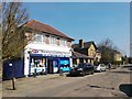
Harmondsworth - High Street Shop
All this area may become Heathrow's third runway .
Image: © James Emmans
Taken: 27 Mar 2017
0.09 miles
10
Tower House, Harmondsworth
https://www.historicengland.org.uk/listing/the-list/list-entry/1194310 .
Image: © Derek Harper
Taken: 26 Apr 2018
0.12 miles