IMAGES TAKEN NEAR TO
Marnham Crescent, GREENFORD, UB6 9SZ
Introduction
This page details the photographs taken nearby to Marnham Crescent, UB6 9SZ by members of the Geograph project.
The Geograph project started in 2005 with the aim of publishing, organising and preserving representative images for every square kilometre of Great Britain, Ireland and the Isle of Man.

There are currently over 7.5m images from over14,400 individuals and you can help contribute to the project by visiting https://www.geograph.org.uk
Image Map
Images are licensed for reuse under creativecommons.org/licenses/by-sa/2.0
Notes
- Clicking on the map will re-center to the selected point.
- The higher the marker number, the further away the image location is from the centre of the postcode.
Image Listing (42 Images Found)
Images are licensed for reuse under creativecommons.org/licenses/by-sa/2.0
Image
Details
Distance
1
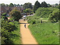
Path from A40 footbridge to Marnham Crescent
This footpath and cycle path leads from a large area of housing around Marnham Crescent to link to paths along the A40, and via the footbridge from which this photo was taken to Long Drive and an industrial area.
Image: © David Hawgood
Taken: 28 May 2012
0.06 miles
2
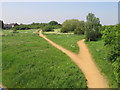
Paths in Northolt and Greenford Countryside Park
These are useful cycle and pedestrian paths. Forking right goes to the A40 road bridge over the canal. Forking left goes to a footbridge, recently repaired, to Horseshoe Crescent which gives easy access to Northala Fields.
Image: © David Hawgood
Taken: 28 May 2012
0.10 miles
3
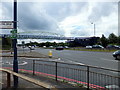
Footbridge over the Western Avenue, Greenford
Image: © PAUL FARMER
Taken: 7 Jul 2012
0.11 miles
4
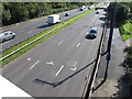
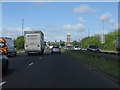
Average speed cameras, shadows, & road markings
On this stretch of the A40 Western Avenue there is a 50 mph speed limit. In this view from a footbridge the photo shows (from bottom to top) shadow of five average speed cameras, L-shaped road markings on which they are aligned, shadow of two instantaneous speed cameras, average speed cameras, instantaneous speed cameras.
Image: © David Hawgood
Taken: 17 Sep 2015
0.11 miles
5
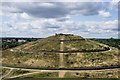
Northolt : Mound of Northala
The highest of the four mounds of Northala Fields. Find out more about these man-made hills at this http://www.londongardenstrust.org/features/northala.htm.
Image: © Jim Osley
Taken: 15 Aug 2019
0.13 miles
6
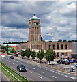
Greenford : former Aladdin Lamp factory
Built in 1931. Architects: C. Nicholas and J.E. Dixon-Spain.
Image: © Jim Osley
Taken: 15 Aug 2019
0.14 miles
7

Do-it-yourself store on A40 Western Avenue in Greenford
This used to be the Aladdin factory and it is a listed building. It was established in 1919 as a subsidiary of the Aladdin Mantle Lamp Company of Connecticut, USA. [Update Jan 2008] The do-it-yourself store has now closed.
Image: © David Hawgood
Taken: 11 Jun 2005
0.14 miles
8

The A40 west bound showing the Aladdin factory tower.
Aladdin Industries Ltd (opened 1932, closed 1982) manufacturer of kerosene lamps and heaters.
Image: © J Taylor
Taken: 29 Oct 2008
0.15 miles
9
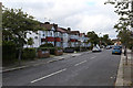
Millet Road
This end of the street and the houses on it date to circa 1950 but may be slightly earlier - it was open fields here in 1935.
Image: © Martin Addison
Taken: 4 Oct 2013
0.15 miles