IMAGES TAKEN NEAR TO
Oldfield Lane South, GREENFORD, UB6 9LQ
Introduction
This page details the photographs taken nearby to Oldfield Lane South, UB6 9LQ by members of the Geograph project.
The Geograph project started in 2005 with the aim of publishing, organising and preserving representative images for every square kilometre of Great Britain, Ireland and the Isle of Man.

There are currently over 7.5m images from over14,400 individuals and you can help contribute to the project by visiting https://www.geograph.org.uk
Image Map
Images are licensed for reuse under creativecommons.org/licenses/by-sa/2.0
Notes
- Clicking on the map will re-center to the selected point.
- The higher the marker number, the further away the image location is from the centre of the postcode.
Image Listing (41 Images Found)
Images are licensed for reuse under creativecommons.org/licenses/by-sa/2.0
Image
Details
Distance
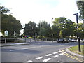
1
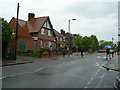
Oldfield Lane South
The buildings on the left are (from left of shot) a Police Station, a Clinic and a Library.
Image: © Danny P Robinson
Taken: 21 May 2006
0.02 miles
2
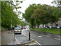
Oldfield Lane South (2)
Looking away from Greenford town centre.
Image: © Danny P Robinson
Taken: 21 May 2006
0.04 miles
3
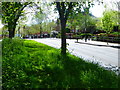
Green footpath at Oldfield Lane
Oldfield Lane is to the left and Oldfield Lane South is to the right. Both roads have pavements on the far side so maybe this is a relic of when Oldfield Lane was a country lane with the footpath at the side.
Image: © Marathon
Taken: 25 Apr 2018
0.04 miles
5
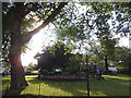
The entrance to Ravenor Park on Oldfield Lane South
Image: © David Howard
Taken: 16 Aug 2014
0.05 miles
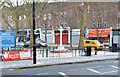
6
Lunchtime in Greenford
School children eat their lunches and young adults mill around outside the local Subway on the corner of The Broadway and Oldfield Lane.
Image: © Martin Addison
Taken: 4 Oct 2013
0.06 miles
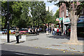
8
Greenford Broadway
The Broadway is the main shopping street in Greenford, in the outer suburbs of West London.
This image was taken on a dull day in early Spring 2023. The tree to the left was still bare from the winter season.
Image: © Malc McDonald
Taken: 1 Apr 2023
0.07 miles
9
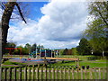
The children's playground in Ravenor Park
Ravenor Park was formerly agricultural land forming part of Ravenor Farm and Costons Farm. Both farms were named after local families. In the 20th century, Greenford gradually transformed from a rural village to a large suburb, including a number of factories. A wave of speculative building followed in the 1920s and 1930s. To preserve some open space, in 1927 Greenford Urban District Council (now Ealing Council) bought a parcel of farmland and turned part of it into a council depot and the rest into a public park. The park opened in October 1928 and was originally known as Costons Farm Recreation Ground, but later changed its name to Ravenor Park. The old farmhouse for Ravenor Farm remained on site until the early 1970s when it became too costly to maintain and was demolished.
For more information about the park, including an expanded history, see https://www.ealing.gov.uk/info/201136/parks_in_the_borough/663/greenford_parks/3 In this photograph Harrow-on-the Hill with its church spire is on the horizon.
Image: © Marathon
Taken: 25 Apr 2018
0.07 miles
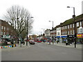
10
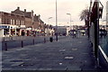
Greenford Broadway November 1981
Greenford Broadway. Ruislip Road looking east towards the Greenford Road junction November 1981.
Image: © MARK CHARNOCK
Taken: 22 Nov 1981
0.07 miles