IMAGES TAKEN NEAR TO
Barnham Road, GREENFORD, UB6 9LP
Introduction
This page details the photographs taken nearby to Barnham Road, UB6 9LP by members of the Geograph project.
The Geograph project started in 2005 with the aim of publishing, organising and preserving representative images for every square kilometre of Great Britain, Ireland and the Isle of Man.

There are currently over 7.5m images from over14,400 individuals and you can help contribute to the project by visiting https://www.geograph.org.uk
Image Map
Images are licensed for reuse under creativecommons.org/licenses/by-sa/2.0
Notes
- Clicking on the map will re-center to the selected point.
- The higher the marker number, the further away the image location is from the centre of the postcode.
Image Listing (36 Images Found)
Images are licensed for reuse under creativecommons.org/licenses/by-sa/2.0
Image
Details
Distance
1
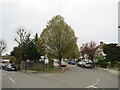
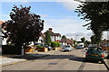
Greenford Gardens, Greenford
Greenford Gardens is a residential road in Greenford, in the outer suburbs of west London.
This image was taken on a dull day in early Spring 2023. Spring blossom was starting to appear on the trees.
Image: © Malc McDonald
Taken: 1 Apr 2023
0.11 miles
2
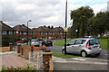
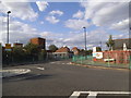
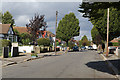
West Ridge Gardens
1950's housing in the suburb of Greenford Magna.
Image: © Martin Addison
Taken: 4 Oct 2013
0.16 miles
3

Farndale Crescent, Greenford
Farndale Crescent is a residential road in Greenford, in the outer suburbs of west London.
Image: © Malc McDonald
Taken: 1 Apr 2023
0.16 miles
4
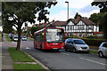
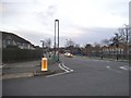
Ferrymead Gardens
An E10 bus on route to Northolt from Ealing comes close to bottoming out as it drops of the speed ramp at the junction with Penn Close.
Image: © Martin Addison
Taken: 4 Oct 2013
0.16 miles
5
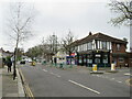
Oldfield Lane South, Greenford
Local shops on Oldfield Lane South in Greenford, in the outer suburbs of west London. Beyond the shops is the entrance to a Hindu temple.
This image was taken on a dull day in early Spring 2023. Trees were still bare from the winter season.
Image: © Malc McDonald
Taken: 1 Apr 2023
0.16 miles
6
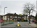
Ravenor Park Road
This road and its housing date to circa 1930.
Image: © Martin Addison
Taken: 4 Oct 2013
0.18 miles
7
Costons Lane at the junction of Oldfield Lane South
Image: © David Howard
Taken: 16 Aug 2014
0.19 miles
8
Oldfield Lane South at the junction of Costons Lane
Image: © David Howard
Taken: 31 Dec 2015
0.19 miles
9
Costons Lane, Greenford
Costons Lane is a residential road in Greenford, in the outer suburbs of west London.
This image was taken on a dull day in early Spring 2023. The tree to the right of the image was still bare from the winter season.
Image: © Malc McDonald
Taken: 1 Apr 2023
0.19 miles
10
Millet Road
A view of the road between Ravenor Park Road and the junction with Greenford Gardens.
Image: © Martin Addison
Taken: 4 Oct 2013
0.20 miles