IMAGES TAKEN NEAR TO
Portland Crescent, GREENFORD, UB6 9EU
Introduction
This page details the photographs taken nearby to Portland Crescent, UB6 9EU by members of the Geograph project.
The Geograph project started in 2005 with the aim of publishing, organising and preserving representative images for every square kilometre of Great Britain, Ireland and the Isle of Man.

There are currently over 7.5m images from over14,400 individuals and you can help contribute to the project by visiting https://www.geograph.org.uk
Image Map
Images are licensed for reuse under creativecommons.org/licenses/by-sa/2.0
Notes
- Clicking on the map will re-center to the selected point.
- The higher the marker number, the further away the image location is from the centre of the postcode.
Image Listing (18 Images Found)
Images are licensed for reuse under creativecommons.org/licenses/by-sa/2.0
Image
Details
Distance
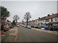
1

Portland Crescent
Terrace housing in Greenford on a dull autumn day.
Image: © James Emmans
Taken: 21 Nov 2019
0.07 miles
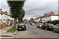
2
Greenford - Ellesmere Road
Terrace Housing.
Image: © James Emmans
Taken: 21 Nov 2019
0.12 miles
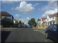
3
Windmill Lane
Although Windmill Lane is an old road the housing along it is relatively recent, dating to circa 1930.
Image: © Martin Addison
Taken: 4 Oct 2013
0.16 miles
4
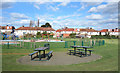
Greenford Recreation Ground
One of Ealing Borough's smaller parks. It has recently received funding for improvements to paths and play and exercise equipment.
Image: © Des Blenkinsopp
Taken: 11 Mar 2019
0.17 miles
6
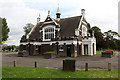
Greenford Park Cemetery
The chapel located at the western end of the cemetery.
Image: © Martin Addison
Taken: 4 Oct 2013
0.17 miles
7
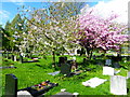
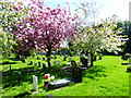
Muslim area in Greenford Park Cemetery
Greenford Park Cemetery was opened as a private cemetery, and later taken over by Greenford Council. It was laid out on former farmland, with a grid of paths leading to a small chapel in the centre. It was declared open for interments 'at exceptionally low charges' in January 1902. All the graves face in the normal east-west direction except in the Muslim section just to the south-west of the chapel where they are all aligned roughly east-south-east to west-north-west to face Mecca. The chapel is unusually bright for a cemetery and looks like it has had a fresh application of white paint.
This is within the Muslim area and the chapel is just behind the blossom.
Image: © Marathon
Taken: 25 Apr 2018
0.18 miles
8
Muslim area in Greenford Park Cemetery
Greenford Park Cemetery was opened as a private cemetery, and later taken over by Greenford Council. It was laid out on former farmland, with a grid of paths leading to a small chapel in the centre. It was declared open for interments 'at exceptionally low charges' in January 1902. All the graves face in the normal east-west direction except in the Muslim section just to the south-west of the chapel where they are all aligned roughly east-south-east to west-north-west to face Mecca. The chapel is unusually bright for a cemetery and looks like it has had a fresh application of white paint.
This is within the Muslim area and the chapel is just behind the blossom.
Image: © Marathon
Taken: 25 Apr 2018
0.18 miles
9
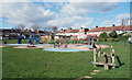
Play Area, Greenford Recreation Ground
Image: © Des Blenkinsopp
Taken: 11 Mar 2019
0.18 miles
10
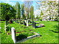
Muslim area in Greenford Park Cemetery
Greenford Park Cemetery was opened as a private cemetery, and later taken over by Greenford Council. It was laid out on former farmland, with a grid of paths leading to a small chapel in the centre. It was declared open for interments 'at exceptionally low charges' in January 1902. All the graves face in the normal east-west direction except in the Muslim section just to the south-west of the chapel where they are all aligned roughly east-south-east to west-north-west to face Mecca. The chapel is unusually bright for a cemetery and looks like it has had a fresh application of white paint.
This is within the Muslim area.
Image: © Marathon
Taken: 25 Apr 2018
0.19 miles