IMAGES TAKEN NEAR TO
Bristol Road, GREENFORD, UB6 8UW
Introduction
This page details the photographs taken nearby to Bristol Road, UB6 8UW by members of the Geograph project.
The Geograph project started in 2005 with the aim of publishing, organising and preserving representative images for every square kilometre of Great Britain, Ireland and the Isle of Man.

There are currently over 7.5m images from over14,400 individuals and you can help contribute to the project by visiting https://www.geograph.org.uk
Image Map
Images are licensed for reuse under creativecommons.org/licenses/by-sa/2.0
Notes
- Clicking on the map will re-center to the selected point.
- The higher the marker number, the further away the image location is from the centre of the postcode.
Image Listing (108 Images Found)
Images are licensed for reuse under creativecommons.org/licenses/by-sa/2.0
Image
Details
Distance
1
Bridport Road, Greenford Industrial Estate
Image: © Des Blenkinsopp
Taken: 9 Oct 2014
0.03 miles
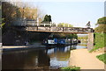
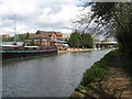
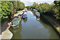
2
Bridge 16A, Paddington Arm, Grand Union Canal
This is the south-west face of the bridge, which is of local importance only. The Mohammedi Park Mosque is seen in the background.
Image: © Dr Neil Clifton
Taken: 12 Apr 2008
0.09 miles
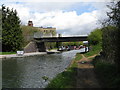
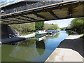
3
Bridge 16A, Paddington Arm, Grand Union Canal
This is the north east face of the bridge. A pipe also crosses here. In the background is the High Line Yachting marina.
Image: © Dr Neil Clifton
Taken: 12 Apr 2008
0.10 miles
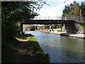
4
High Line Yachting marina, Paddington Arm, Grand Union Canal
Bridge 16A is seen in the distance.
Image: © Dr Neil Clifton
Taken: 12 Apr 2008
0.10 miles
5
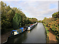
Grand Union Canal at Northolt
From the footbridge where the Dog Rose Ramble meets the Grand Union Canal Walk.
Image: © Des Blenkinsopp
Taken: 9 Oct 2014
0.10 miles
6
The Grand Union Canal east of Northolt church
Image: © Stefan Czapski
Taken: 24 Apr 2022
0.10 miles
7
The Aladdin Tower, A40 Westway, Greenford.
Photograph was taken from the foot bridge over the A40.
Image: © J Taylor
Taken: 29 Oct 2008
0.11 miles
9
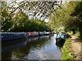
Looking along the Paddington Arm of the Grand Union Canal at Northolt
The Paddington Arm of the then Grand Junction Canal was opened in 1801 from Bull's Bridge near Southall to Paddington Basin. The canals were initially a success, particularly for transporting coal, building materials and other bulky loads, but the rise of the railways not long after the canals were built substantially reduced their importance. Now they are primarily a leisure facility. The Paddington Arm was one of the last to see the old-fashioned style of regular commercial traffic of paired narrow boats carrying the traditional materials such as coal, oils, and tar. The Paddington Arm now sees regular commercial traffic, usually in the form of aggregates.
The towpath is followed by the Grand Union Canal Walk, and here also by the Dog Rose Ramble - see http://annierak.hoofbags.me.uk/dogroseramble.html which comes along the towpath ahead and then crosses the bridge here.
Image: © Marathon
Taken: 20 Apr 2016
0.11 miles