IMAGES TAKEN NEAR TO
Old Church Lane, GREENFORD, UB6 8TT
Introduction
This page details the photographs taken nearby to Old Church Lane, UB6 8TT by members of the Geograph project.
The Geograph project started in 2005 with the aim of publishing, organising and preserving representative images for every square kilometre of Great Britain, Ireland and the Isle of Man.

There are currently over 7.5m images from over14,400 individuals and you can help contribute to the project by visiting https://www.geograph.org.uk
Image Map
Images are licensed for reuse under creativecommons.org/licenses/by-sa/2.0
Notes
- Clicking on the map will re-center to the selected point.
- The higher the marker number, the further away the image location is from the centre of the postcode.
Image Listing (119 Images Found)
Images are licensed for reuse under creativecommons.org/licenses/by-sa/2.0
Image
Details
Distance
1
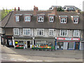
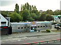
Shops by the A40 at Perivale
Some of the shops in this parade have closed. They are just over the road from a Tesco supermarket, and the large filling station nearby has a substantial shop. But there are still useful shops here - I have shopped here a number of times when they have been on my cycle route.
Image: © David Hawgood
Taken: 6 Apr 2011
0.01 miles
2
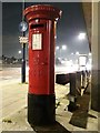
Perivale: postbox № UB6 183, Western Avenue
This George V-reign postbox stands underneath a footbridge over the busy A40 Western Avenue, by the dead-end of Old Church Lane just to our right.
Image: © Chris Downer
Taken: 20 Jan 2019
0.02 miles
4
Fayre & Square, Perivale, 2012
Somewhere to eat, not obviously to drink at this time, although it later became a pub with a different name. Apparently associated with a Premier Inn in the next block along, in the same grounds.
Image: © Robin Webster
Taken: 13 Oct 2012
0.03 miles
5

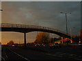
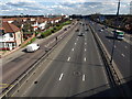
A40 at Perivale
The A40 trunk road passing through Perivale, in the suburbs of west London.
This image was taken on a Saturday afternoon, with plenty of traffic using the road.
Image: © Malc McDonald
Taken: 2 Jun 2018
0.03 miles
6
Starvin' Marvin's Diner, Perivale
A building built to resemble an American railroad stainless steel dining car.
Image: © Robin Webster
Taken: 13 Oct 2012
0.04 miles
7
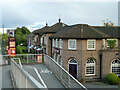
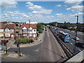
A40 at Perivale
The view seen in Image taken a little earlier in the day, from the same footbridge as Image which looks the other way. The houses on the left are Teignmouth Gardens, beside the B456 which runs parallel to the dual carriageway. The Hoover Building (Image) can just be seen 300 metres away.
Image: © Derek Harper
Taken: 19 Mar 2012
0.04 miles
8
A40 - Western Avenue, Perivale
Looking towards the Medway Underpass the next junction up.
Image: © Phillip Perry
Taken: 2 Nov 2008
0.04 miles
9
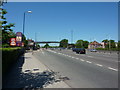
Western Avenue, Perivale
Looking west
Image: © Alexander P Kapp
Taken: 23 May 2010
0.04 miles
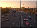
10
A40 Western Avenue and slip-road, Perivale
Western Avenue is a busy trunk road in west London's suburbs, which forms part of the A40. The road to its left is a two-way slip road for local traffic, running alongside the dual carriageway.
This image was taken from a pedestrian footbridge across the A40.
Image: © Malc McDonald
Taken: 2 Jun 2018
0.05 miles