IMAGES TAKEN NEAR TO
Perivale Lane, GREENFORD, UB6 8TS
Introduction
This page details the photographs taken nearby to Perivale Lane, UB6 8TS by members of the Geograph project.
The Geograph project started in 2005 with the aim of publishing, organising and preserving representative images for every square kilometre of Great Britain, Ireland and the Isle of Man.

There are currently over 7.5m images from over14,400 individuals and you can help contribute to the project by visiting https://www.geograph.org.uk
Image Map
Images are licensed for reuse under creativecommons.org/licenses/by-sa/2.0
Notes
- Clicking on the map will re-center to the selected point.
- The higher the marker number, the further away the image location is from the centre of the postcode.
Image Listing (116 Images Found)
Images are licensed for reuse under creativecommons.org/licenses/by-sa/2.0
Image
Details
Distance
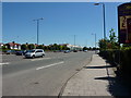
1
Old Hoover Building
Now a large supermarket
Image: © Vicky Ayech
Taken: 16 Apr 2005
0.04 miles
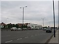
2
Western Avenue, Perivale
Looking east
Image: © Alexander P Kapp
Taken: 23 May 2010
0.04 miles
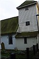
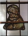
4
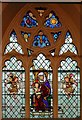
St Mary, Perivale Lane, Greenford - Window
Image: © John Salmon
Taken: 1 Dec 2001
0.05 miles
5
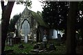
St. Mary's Church, Perivale
No longer a church, the small graveyard surrounding the building is open to the public, the church dates to about 1135AD.
See: http://www.st-marys-perivale.org.uk
Image: © Phillip Perry
Taken: 2 Nov 2008
0.05 miles
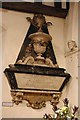
6
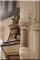
St Mary, Perivale Lane, Greenford - Wall monument
Image: © John Salmon
Taken: 1 Dec 2001
0.05 miles
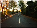
7
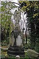
St Mary, Perivale Lane, Greenford - Churchyard
Image: © John Salmon
Taken: 1 Dec 2001
0.05 miles
9
St Mary, Perivale Lane, Greenford - Wall monument
Image: © John Salmon
Taken: 1 Dec 2001
0.06 miles
10
St Mary, Perivale Lane, Greenford - Window
Image: © John Salmon
Taken: 1 Dec 2001
0.06 miles