IMAGES TAKEN NEAR TO
Hill Rise, GREENFORD, UB6 8PF
Introduction
This page details the photographs taken nearby to Hill Rise, UB6 8PF by members of the Geograph project.
The Geograph project started in 2005 with the aim of publishing, organising and preserving representative images for every square kilometre of Great Britain, Ireland and the Isle of Man.

There are currently over 7.5m images from over14,400 individuals and you can help contribute to the project by visiting https://www.geograph.org.uk
Image Map
Images are licensed for reuse under creativecommons.org/licenses/by-sa/2.0
Notes
- Clicking on the map will re-center to the selected point.
- The higher the marker number, the further away the image location is from the centre of the postcode.
Image Listing (59 Images Found)
Images are licensed for reuse under creativecommons.org/licenses/by-sa/2.0
Image
Details
Distance
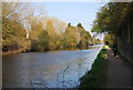
8
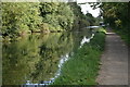
Railway bridge over the Paddington Arm
This is the north-east face of the bridge carrying London Transport's Central Line as well as Great Western local trains over the Paddington Arm.
Image: © Dr Neil Clifton
Taken: 12 Apr 2008
0.16 miles
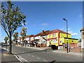
9
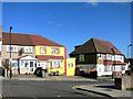
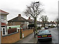
Think Outside The Beige
No suburban drab here.
A yellow house on Hill Rise, Greenford.
Image: © Des Blenkinsopp
Taken: 27 Oct 2014
0.16 miles
