IMAGES TAKEN NEAR TO
Birkbeck Avenue, GREENFORD, UB6 8LX
Introduction
This page details the photographs taken nearby to Birkbeck Avenue, UB6 8LX by members of the Geograph project.
The Geograph project started in 2005 with the aim of publishing, organising and preserving representative images for every square kilometre of Great Britain, Ireland and the Isle of Man.

There are currently over 7.5m images from over14,400 individuals and you can help contribute to the project by visiting https://www.geograph.org.uk
Image Map
Images are licensed for reuse under creativecommons.org/licenses/by-sa/2.0
Notes
- Clicking on the map will re-center to the selected point.
- The higher the marker number, the further away the image location is from the centre of the postcode.
Image Listing (30 Images Found)
Images are licensed for reuse under creativecommons.org/licenses/by-sa/2.0
Image
Details
Distance
6
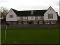
London Marathon Playingfields Clubhouse
Close to Greenford Central Line Underground.
Image: © John Rigby
Taken: 24 Feb 2007
0.14 miles
7
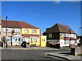
Think Outside The Beige
No suburban drab here.
A yellow house on Hill Rise, Greenford.
Image: © Des Blenkinsopp
Taken: 27 Oct 2014
0.14 miles
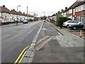
9

Hill Rise looking towards Belle Vue, Greenford
You can just see the railway at the back
Image: © David Howard
Taken: 31 Dec 2015
0.16 miles
