IMAGES TAKEN NEAR TO
Rydal Crescent, GREENFORD, UB6 8DY
Introduction
This page details the photographs taken nearby to Rydal Crescent, UB6 8DY by members of the Geograph project.
The Geograph project started in 2005 with the aim of publishing, organising and preserving representative images for every square kilometre of Great Britain, Ireland and the Isle of Man.

There are currently over 7.5m images from over14,400 individuals and you can help contribute to the project by visiting https://www.geograph.org.uk
Image Map
Images are licensed for reuse under creativecommons.org/licenses/by-sa/2.0
Notes
- Clicking on the map will re-center to the selected point.
- The higher the marker number, the further away the image location is from the centre of the postcode.
Image Listing (46 Images Found)
Images are licensed for reuse under creativecommons.org/licenses/by-sa/2.0
Image
Details
Distance
1
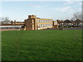
Vicar's Green Primary School
View from footpath beside the school,
Image: © David Hawgood
Taken: 19 Jan 2007
0.08 miles
4
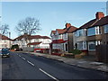
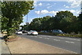
Rydal Crescent from Western Avenue
This suburban road loops round back to Western Avenue but is blocked the other end. It provides a cycle route parallel to the busy main road on a section past a school.
Image: © David Hawgood
Taken: 19 Jan 2007
0.09 miles
6
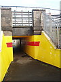
Subway under the Central Line
This narrow footpath meanders from Rydal Crescent to Wadsworth Road and Vicar's Green School.
Image: © David Hawgood
Taken: 19 Jan 2007
0.10 miles
7
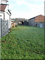
Water main corridor and railway bridge
This green strip between buildings off Rydal Crescent has beneath it a Metropolitan Water Board 42" and 48" main; see description of this main http://middlesexcountycouncil.org.uk/index.php?option=com_content&task=category§ionid=9&id=17&Itemid=35 in Nick Papadimitriou's Middlesex County Council website. The main runs from Hampstead Garden Suburb to Hampton Wick. Here it has a bridge under the Central Line.
Thanks to John Webb for telling me that this is the line of a water main.
Image: © David Hawgood
Taken: 19 Jan 2007
0.10 miles
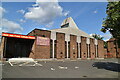
9
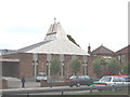
St John Fisher Roman Catholic Church, Perivale
The address is "Langdale Gardens" which is along Western Avenue
Image: © David Hawgood
Taken: 11 Jun 2005
0.12 miles
10
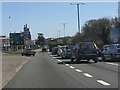
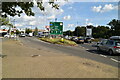
Western Avenue (A40) at Alperton Lane
Yes, that really is a Triumph Dolomite turning off the A40. One of the cars of my L-plate days. No power steering, a gearbox which needed a winch to shift it and acceleration of 0-60 the same day if you were lucky.
Image: © Peter Whatley
Taken: 1 Apr 2012
0.12 miles