IMAGES TAKEN NEAR TO
Teignmouth Gardens, GREENFORD, UB6 8BX
Introduction
This page details the photographs taken nearby to Teignmouth Gardens, UB6 8BX by members of the Geograph project.
The Geograph project started in 2005 with the aim of publishing, organising and preserving representative images for every square kilometre of Great Britain, Ireland and the Isle of Man.

There are currently over 7.5m images from over14,400 individuals and you can help contribute to the project by visiting https://www.geograph.org.uk
Image Map
Images are licensed for reuse under creativecommons.org/licenses/by-sa/2.0
Notes
- Clicking on the map will re-center to the selected point.
- The higher the marker number, the further away the image location is from the centre of the postcode.
Image Listing (141 Images Found)
Images are licensed for reuse under creativecommons.org/licenses/by-sa/2.0
Image
Details
Distance
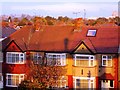
1
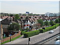
Houses by Western Avenue, Perivale
These are semi-detached houses built around 1930. The large white building on the right is the Hoover building. View from footbridge over Western Avenue.
Image: © David Hawgood
Taken: 6 Apr 2011
0.02 miles
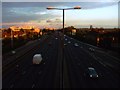
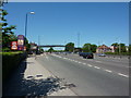
3
A40 Western Avenue heading east, Perivale
Image: © Robin Webster
Taken: 13 Oct 2012
0.03 miles
4
View along the A40 Westway from the Old Church Lane footbridge #2
Looking east-southeast. The art-deco Hoover Building can be seen on the left.
Image: © Robert Lamb
Taken: 5 Jun 2012
0.04 miles
5
That's me on the rooftop
That shadow on the roof of the middle of those 3 houses is ME! I can't prove it any other way, you'll just have to trust me.......
I must be about 75 yards away on the footbridge crossing the Western Avenue as the sun is setting behind me.
Image: © Phillip Perry
Taken: 2 Nov 2008
0.04 miles
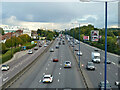
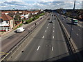
6
Western Avenue, Perivale
Looking west
Image: © Alexander P Kapp
Taken: 23 May 2010
0.05 miles
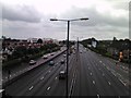
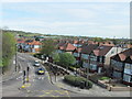
7
A40 at Perivale
The view seen in Image taken a little earlier in the day, from the same footbridge as Image which looks the other way. The houses on the left are Teignmouth Gardens, beside the B456 which runs parallel to the dual carriageway. The Hoover Building (Image) can just be seen 300 metres away.
Image: © Derek Harper
Taken: 19 Mar 2012
0.06 miles
8
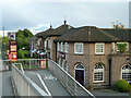
Horsenden Lane, Perivale
View from footbridge over Western Avenue. Road surface markings include a 20 mph speed limit, an advanced stop line for cyclists at the traffic lights, yellow cross-hatching in the junction to show an area where you are not allowed to stop, and traffic calming pillows (three across the road).
Image: © David Hawgood
Taken: 6 Apr 2011
0.06 miles
9
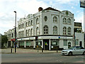
Teignmouth Parade, Perivale
A locally listed building consisting principally of a bank. It is finished in white tiles, with some green ones, including a green motif rather like pineapple leaves which is not too dissimilar to a motif used on the nearby Hoover Building.
Image: © Robin Webster
Taken: 13 Oct 2012
0.07 miles
10
Fayre & Square, Perivale, 2012
Somewhere to eat, not obviously to drink at this time, although it later became a pub with a different name. Apparently associated with a Premier Inn in the next block along, in the same grounds.
Image: © Robin Webster
Taken: 13 Oct 2012
0.07 miles