IMAGES TAKEN NEAR TO
Bennetts Avenue, GREENFORD, UB6 8AX
Introduction
This page details the photographs taken nearby to Bennetts Avenue, UB6 8AX by members of the Geograph project.
The Geograph project started in 2005 with the aim of publishing, organising and preserving representative images for every square kilometre of Great Britain, Ireland and the Isle of Man.

There are currently over 7.5m images from over14,400 individuals and you can help contribute to the project by visiting https://www.geograph.org.uk
Image Map
Images are licensed for reuse under creativecommons.org/licenses/by-sa/2.0
Notes
- Clicking on the map will re-center to the selected point.
- The higher the marker number, the further away the image location is from the centre of the postcode.
Image Listing (88 Images Found)
Images are licensed for reuse under creativecommons.org/licenses/by-sa/2.0
Image
Details
Distance
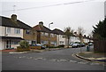
1
Bennett's Avenue
Route of the Capital Ring.
Image: © N Chadwick
Taken: 11 Apr 2013
0.01 miles
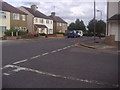
2
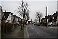
Middleton Avenue, Greenford
Middleton Avenue is a residential road in Greenford, in the suburbs of west London.
This image was taken on a dull day in early March. At this time of year, most of the trees are still bare for the winter season, although new leaves will soon grow.
Image: © Malc McDonald
Taken: 5 Mar 2023
0.05 miles
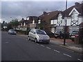
3
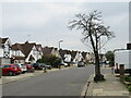
Bennetts Avenue, Greenford
Bennetts Avenue is a residential road in Greenford, in the suburbs of west London. It is on the route of the Capital Ring long distance path.
This image was taken on a dull day in early March. At this time of year, trees are still bare for the winter season, although early spring buds are starting to appear on the tree on the opposite side of the road.
Image: © Malc McDonald
Taken: 5 Mar 2023
0.06 miles
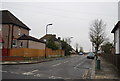
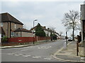
6
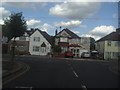
Bennetts Avenue at the junction of Downing Drive
Image: © David Howard
Taken: 22 Aug 2012
0.06 miles
7
Bennetts Avenue at the junction of Downing Drive
Image: © David Howard
Taken: 22 Aug 2012
0.06 miles
9
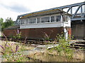
Greenford East Signal Box
The signalbox is a rare survivor of mechanical signalling in the London area. To a Great Western Railway design, the windows and brickwork show that it has been extended (albeit in a style to match the original fabric) and a relay room added as this facility took over control of other local signaboxes.
Photograph taken under the supervision of Network Rail local management.
Image: © Peter Whatley
Taken: 17 Jul 2010
0.08 miles
10
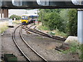
Greenford - the shuttle approaches
A train from London Paddington approaches the junction between the curve onto the former main line from Paddington to Birmingham and the link to the bay platform at Greenford station. The foreground metalwork forms part of a girder bridge carrying the eastbound Central Line track.
Photographed under the supervision of Network Rail management.
Image: © Peter Whatley
Taken: 17 Jul 2010
0.08 miles