IMAGES TAKEN NEAR TO
Gilbert White Close, GREENFORD, UB6 7FJ
Introduction
This page details the photographs taken nearby to Gilbert White Close, UB6 7FJ by members of the Geograph project.
The Geograph project started in 2005 with the aim of publishing, organising and preserving representative images for every square kilometre of Great Britain, Ireland and the Isle of Man.

There are currently over 7.5m images from over14,400 individuals and you can help contribute to the project by visiting https://www.geograph.org.uk
Image Map
Images are licensed for reuse under creativecommons.org/licenses/by-sa/2.0
Notes
- Clicking on the map will re-center to the selected point.
- The higher the marker number, the further away the image location is from the centre of the postcode.
Image Listing (115 Images Found)
Images are licensed for reuse under creativecommons.org/licenses/by-sa/2.0
Image
Details
Distance
1
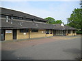
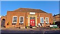
Perivale Community Centre
The Centre is on the west side of Horsenden Lane South.
Image: © Nigel Cox
Taken: 5 May 2008
0.03 miles
2
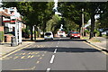
Horsenden Lane North at the junction of Bilton Road
Image: © David Howard
Taken: 17 Apr 2014
0.06 miles
3
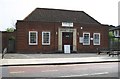
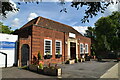
Perivale Library
Located on the east side of Horsenden Lane South the noticeboards outside refer to the recent local government elections.
Image: © Nigel Cox
Taken: 5 May 2008
0.07 miles
4

Cafe and Hope Christian Centre, Perivale
Cafe Rendezvous is part of Hope Christian Centre http://hopecc.co.uk/about-us .
Image: © David Hawgood
Taken: 6 Apr 2011
0.07 miles
5
Perivale Library
This is one of a network of local libraries in the London Borough of Ealing managed by community groups. Against a background of funding cuts, Perivale Community Hive took over the library from the borough council in summer 2020.
Image: © Mark Percy
Taken: 21 Jan 2023
0.07 miles
9
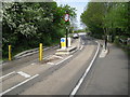
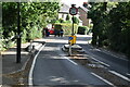
Perivale: Ballot Box Bridge on Horsenden Lane South
The problems of the use by 21st century road traffic of a late 18th century canal bridge are illustrated here, on the southern approach to the bridge along Horsenden Lane South. Width restrictions, imposed by the posts and reinforced by the raised kerbing, also create weight restrictions, while the traffic lights show one way vehicle movement only over the bridge.
Image: © Nigel Cox
Taken: 5 May 2008
0.10 miles