IMAGES TAKEN NEAR TO
Whitton Avenue East, GREENFORD, UB6 0QQ
Introduction
This page details the photographs taken nearby to Whitton Avenue East, UB6 0QQ by members of the Geograph project.
The Geograph project started in 2005 with the aim of publishing, organising and preserving representative images for every square kilometre of Great Britain, Ireland and the Isle of Man.

There are currently over 7.5m images from over14,400 individuals and you can help contribute to the project by visiting https://www.geograph.org.uk
Image Map
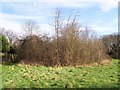
Images are licensed for reuse under creativecommons.org/licenses/by-sa/2.0
Notes
- Clicking on the map will re-center to the selected point.
- The higher the marker number, the further away the image location is from the centre of the postcode.
Image Listing (42 Images Found)
Images are licensed for reuse under creativecommons.org/licenses/by-sa/2.0
Image
Details
Distance

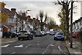
3
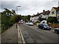
Rosewood Avenue
Viewing north, an uphill section of the road. Close to Horsenden Hill.
Image: © James Emmans
Taken: 17 Aug 2019
0.09 miles
5
Robin Hood Way
Viewed from Rosewood Ave
Image: © Russell Trebor
Taken: 14 Jan 2007
0.11 miles
7
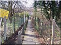
Alley
Alley from Rosewood Ave to Bracewell Ave
Image: © Russell Trebor
Taken: 14 Jan 2007
0.13 miles
8
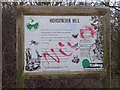
Graffiti Hit Notice
Horsenden Hill Notice board
Image: © Russell Trebor
Taken: 14 Jan 2007
0.13 miles
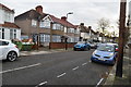
9
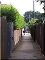
Alley - Sudbury Town
Eastcote Ave leading to Sudbury Heights Ave
Image: © Russell Trebor
Taken: 17 Jun 2006
0.13 miles
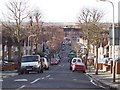
10
Sudbury - Whitton Avenue East
Taken from Allendale Road.
Image: © Peter Whatley
Taken: 7 Apr 2010
0.13 miles