IMAGES TAKEN NEAR TO
Horsenden Crescent, GREENFORD, UB6 0JF
Introduction
This page details the photographs taken nearby to Horsenden Crescent, UB6 0JF by members of the Geograph project.
The Geograph project started in 2005 with the aim of publishing, organising and preserving representative images for every square kilometre of Great Britain, Ireland and the Isle of Man.

There are currently over 7.5m images from over14,400 individuals and you can help contribute to the project by visiting https://www.geograph.org.uk
Image Map
Images are licensed for reuse under creativecommons.org/licenses/by-sa/2.0
Notes
- Clicking on the map will re-center to the selected point.
- The higher the marker number, the further away the image location is from the centre of the postcode.
Image Listing (83 Images Found)
Images are licensed for reuse under creativecommons.org/licenses/by-sa/2.0
Image
Details
Distance
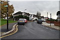
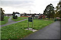
3
Ridding Lane Open Space, Sudbury, with flats beyond
This is just at the Northern limit of the London Borough of Ealing.
Image: © David Hawgood
Taken: 11 Jun 2005
0.08 miles
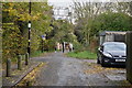
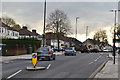
6
Harrow on The Hill : Ridding Lane
Ridding Lane off Greenford Road.
Image: © Lewis Clarke
Taken: 12 Sep 2020
0.11 miles
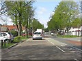
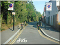
7

Harrow on The Hill : Greenford Road
Looking along Greenford Road.
Image: © Lewis Clarke
Taken: 12 Sep 2020
0.12 miles
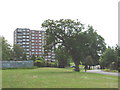
9
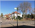
Capital Ring Corner
On one of the frequent roadside sections of the Capital Ring path, featuring one of the path waymarks.
The white building opposite is a Polish dentist's.
Image: © Des Blenkinsopp
Taken: 4 Nov 2014
0.14 miles
10

Sudbury Hill station, Piccadilly Line
Image: © Peter Whatley
Taken: 2 Apr 2012
0.14 miles