IMAGES TAKEN NEAR TO
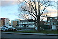
Ruislip Road, NORTHOLT, UB5 6BJ
Introduction
This page details the photographs taken nearby to Ruislip Road, UB5 6BJ by members of the Geograph project.
The Geograph project started in 2005 with the aim of publishing, organising and preserving representative images for every square kilometre of Great Britain, Ireland and the Isle of Man.

There are currently over 7.5m images from over14,400 individuals and you can help contribute to the project by visiting https://www.geograph.org.uk
Image Map
Images are licensed for reuse under creativecommons.org/licenses/by-sa/2.0
Notes
- Clicking on the map will re-center to the selected point.
- The higher the marker number, the further away the image location is from the centre of the postcode.
Image Listing (69 Images Found)
Images are licensed for reuse under creativecommons.org/licenses/by-sa/2.0
Image
Details
Distance
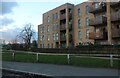
1
Flats on Rectory Park Avenue, Northolt
Image: © David Howard
Taken: 10 Feb 2021
0.02 miles
2
Flats on Rectory Park Avenue, Northolt
Rectory Park is behind
Image: © David Howard
Taken: 10 Feb 2021
0.03 miles
3
Building beside Rectory Park
The Rectory Park Estate is the subject of an extensive housing regeneration program by Ealing Council. https://www.ealing.gov.uk/info/201104/housing_regeneration/375/rectory_park_estate/1
Image: © Des Blenkinsopp
Taken: 11 Mar 2019
0.08 miles
4
The Blue Orchid on Ruislip Road, Northolt
One of many pubs which became an Indian restaurant
Image: © David Howard
Taken: 10 Feb 2021
0.08 miles
5
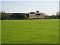
Rectory Park, Northolt
That is not a pond, there's been loads of rain followed by snow, and most water is currently ice.
Image: © David Howard
Taken: 10 Feb 2021
0.10 miles
6
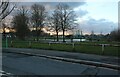
The Rectory Park playing fields.
Showing part of the housing estate along Rectory Park Avenue.
Image: © J Taylor
Taken: 29 Oct 2008
0.10 miles
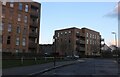
7
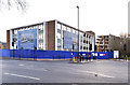
Former Taylor Woodrow buildings, Northolt (2)
Buildings at the junction of Ruislip Road and Taywood Road. Awaiting demolition prior to the erection of residential properties.
Image: © MrC
Taken: 5 Dec 2010
0.11 miles
8
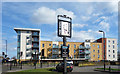
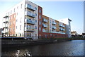
Outside The Civil Engineer
The Civil Engineer is a pub/restaurant on Ruislip Road. Behind the apartment block is the Grand Union Canal, hence the pub name.
Is Thomas Telford the engineer in the picture? (canal historians confirm or correct please)
Image: © Des Blenkinsopp
Taken: 11 Mar 2019
0.12 miles
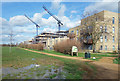
9

Montgomery House, Northolt
A block of flats, not quite finished in this autumn 2012 view. The name is derived from a canal, not the military man. All the blocks on this estate are named after canals or prominent places on them.
Image: © Robin Webster
Taken: 13 Oct 2012
0.14 miles