IMAGES TAKEN NEAR TO
Rowdell Road, NORTHOLT, UB5 6AG
Introduction
This page details the photographs taken nearby to Rowdell Road, UB5 6AG by members of the Geograph project.
The Geograph project started in 2005 with the aim of publishing, organising and preserving representative images for every square kilometre of Great Britain, Ireland and the Isle of Man.

There are currently over 7.5m images from over14,400 individuals and you can help contribute to the project by visiting https://www.geograph.org.uk
Image Map
Images are licensed for reuse under creativecommons.org/licenses/by-sa/2.0
Notes
- Clicking on the map will re-center to the selected point.
- The higher the marker number, the further away the image location is from the centre of the postcode.
Image Listing (117 Images Found)
Images are licensed for reuse under creativecommons.org/licenses/by-sa/2.0
Image
Details
Distance
4
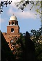
Mohammedi Park Masjid Complex, Northolt Bohra Mosque
Image: © N Chadwick
Taken: 29 Mar 2014
0.03 miles
5
Mohammedi Park Masjid Complex, Northolt Bohra Mosque
Image: © N Chadwick
Taken: 29 Mar 2014
0.04 miles
6
Mohammedi Park Masjid Complex, Northolt Bohra Mosque
Image: © N Chadwick
Taken: 29 Mar 2014
0.05 miles
7
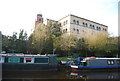
Grand Union at Northolt
A footpath bridge, over the Grand Union Canal, with the Northolt mosque behind.
Image: © Michael Askin
Taken: 29 Jan 2004
0.05 miles
8

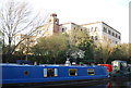
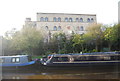
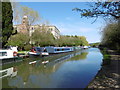
The Paddington Arm of the Grand Union Canal at Northolt
The Paddington Arm of the then Grand Junction Canal was opened in 1801 from Bull's Bridge near Southall to Paddington Basin. The canals were initially a success, particularly for transporting coal, building materials and other bulky loads, but the rise of the railways not long after the canals were built substantially reduced their importance. Now they are primarily a leisure facility. The Paddington Arm was one of the last to see the old-fashioned style of regular commercial traffic of paired narrow boats carrying the traditional materials such as coal, oils, and tar. The Paddington Arm now sees regular commercial traffic, usually in the form of aggregates.
The towpath is followed by the Grand Union Canal Walk, and here also by the Dog Rose Ramble - see http://annierak.hoofbags.me.uk/dogroseramble.html The building behind the trees is the Mohammedi Park Masjid Complex.
Image: © Marathon
Taken: 20 Apr 2016
0.06 miles
9
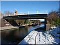
Northolt, Bridge No 16A
Footbridge across Grand Union Canal (Paddington Branch); dated 1923.
Image: © Mike Faherty
Taken: 2 Apr 2016
0.06 miles
10
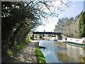
The Paddington Arm of the Grand Union Canal at Northolt
The Paddington Arm of the then Grand Junction Canal was opened in 1801 from Bull's Bridge near Southall to Paddington Basin. The canals were initially a success, particularly for transporting coal, building materials and other bulky loads, but the rise of the railways not long after the canals were built substantially reduced their importance. Now they are primarily a leisure facility. The Paddington Arm was one of the last to see the old-fashioned style of regular commercial traffic of paired narrow boats carrying the traditional materials such as coal, oils, and tar. The Paddington Arm now sees regular commercial traffic, usually in the form of aggregates.
The towpath is followed by the Grand Union Canal Walk. The building behind is the Mohammedi Park Masjid Complex.
Image: © Marathon
Taken: 20 Apr 2016
0.06 miles